| |
| |
Passo di Monte Rest There are mountain passes
you read about and then plan every detail.
And then it all happens in a big crowd.
There there are summits you find the day
before on the map. There is not another
soul riding along, and even motorcyclist
can be counted on the hands you already
have. The weather is perfect and the
sights are great. -Not sure which one is
better. But this one belongs in the second
category for me.
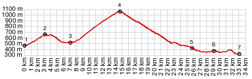
The road reaches a ~20m higher
elevation immediately before crossing the
pass. The top is forested without views.
Even a short trail on the prominent dirt
road leading higher from the summit does not
go to any kind of overlook. The road shares
the pass with a power line.
From
South. (descirbed downwards) The
narrow road takes big steps downhill in the
form of switchbacks below a hulking
limestone. There are 6 in the upper
staircase and about 20 in the lower. Upper
and lower Tramonti are picturesque valley
meadows with well kept modern homes. Even
though there is nothing old or medieval
about these locations, Tramonti di Sopra has
a attractive town square center where
everything seems to have corners but no 90
degree angles -little if any tourist
business.
Dayride with this point as
highest summit:
COMPLETELY PAVED: ( < Sella Di Razzo / Sella Di Rioda | Passo Della Pura > ) Passo Rest , Sella Chiunzutan , jct SP51 - Val di Refugio(sh) , SP57 Padis di Sotto s(u): Ampezzo > Passo Resto > Tramonti di Sopra with sightseeing detour > Tramonti di Sotta > Campone > SP57 Pradis di Sotto s(u) > jct SP51 - Val di Rifugio(sh) > Pielungo > San Francesco > Pocis > Sella Chiunzutan > Chiacis > Sp72 north > Villa > Villa Santina > Enemonzo > back to starting point in Ampezzo: 66.1miles with 8160ft of climbing in 7:04hrs (garmin etrex30 r5:21.9.20)  |
|
|
advertisement |
|
|
advertisement |