|
|||||||||||||||||
|
|
|||||||||||||||||
| |
|
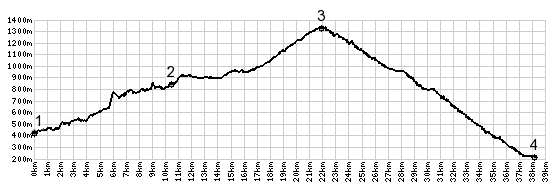
Col de Porte
Following the center along the length of the Chartreuse
Range is easily accomplished in a day. Along the way you
pass through deep valleys and go over three passes, this
one, and also Col du Granier
and Col du Cucheron. This
is the highest one of the three and exits the range in a
long, steep decline into Grenoble. This section also has a
lot more traffic, than what I had become used to in the
Chartreuse.
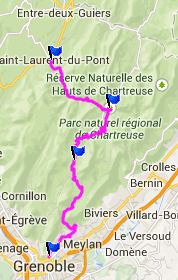
Approaches
There are two options for the lower approach. Either stay in
the bottom of the valley along the main road, or
start climbing out of the valley earlier on C8. This is
longer but more scenic, and you could change your mind at the
last minute and ride over Col de Coq
instead, because this road serves as approach for both. D57B
then leads over to the main road to Col de Porte, and the scenic
action is pretty much over on this side. The road stays in the
forest, and reaches a top with several modern, somewhat out of
place looking buildings. From South. (described downwards)
About 175 meters below the summit the road reaches a shoulder
point, which is also a named pass: Col de Palaquit. The point
marks a second option to descend, on a smaller road. I stayed on
the main approach and traffic was much heaver than during the
rest of the day. This is no surprise, because the road descends
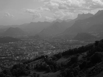
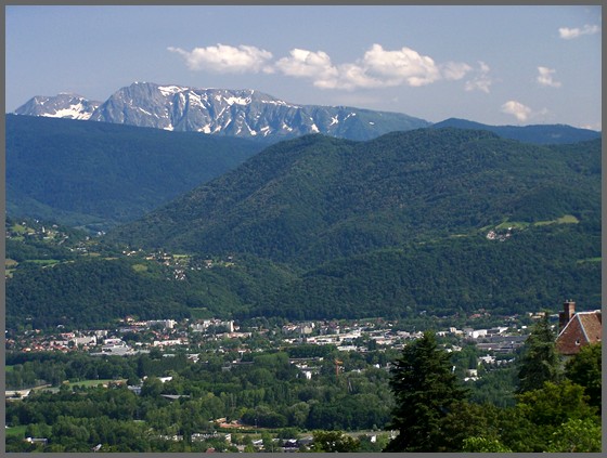
straight into the center of Grenoble. If the haze from pollution
permits it, you can identify all the mountain areas that join
together around this mountain city. Across the way up in the
sky: the Belledonne Range, to the south, lower but with steep
surrounding cliffs: the Vercors. To the east is a paved road to
over 2000m in the Chamrouse Mountains area, and last but not
least, the cliffs we are descending: the Chartreuse. The road
does not level out until it reaches a bridge over the river
Isere, adjacent to the city center.
both pictures are from the south side, looking over Grenoble, above in black and white haze, below of its western outskirts
Historical Notes:
|
|
|
advertisement |
|
|
advertisement |