| |
| |
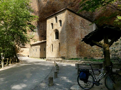
Monastario San Juan de la Pena s(u) It's not a pass, not even an Alto,
But it turned out to be the highest and most
interesting part of my route over Puerto
de Oroel. There are two monasteries along
the way, and the scenery is a happening thing
further down on the northern side.
The turnoff to Botaya is one of
those summt-appearance points, until you actually
get there. By this time the road traverses the
highest ridge, flanking the valley of the Rio
Aragon, the main ridge of the Pyrenees forms an
imposing backdrop behind the valley. Before reaching the actual top the
road enters a forest and heads straight for the
facade of a hermitage in the forest. The
Monastario San Juan de la Pena is the highest
point, though you would not have guessed it from
the deep forest surrounding it.The building itself
strikes me as having a little bit of an
institutional look, with a made-for-movies-like
facade attached to one end.
The second monastery looks maybe a
bit more intriguing, at least to an average
tourist like myself. It is a smaller structure
built into an alcove. Back on the bike, the road makes a
large U turn traverse inside a low hanging valley
with great views downvalley.It is a fast descend.
Another village on the way down is worth a look:
Santa Cruz de la Seros
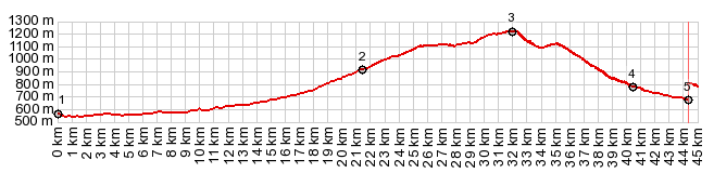
Dayride with this point as
highest summit COMPLETELY PAVED ( < Col St Pierre Martin | Alto de Zuriza > ) Mon San Juan de la Pena s(u) , Puerto de Oroel : just north of Jaca > A1205 south <> out and back a few km beyond Parador de Oroel >> Puerto de Oroel > A1603 north > Mon San Juan de la Pena s(u) > Cruz de la Serra < N240 east back to starting point north of Jaca : 43.4miles with 3990ft of climbing in 4:22hrs (garmin etrex30 r5:22.10.18). Notes: the day also included a hike to the top of Pico Oroel: hike+bike: 48.3miles with 5800ft of climbing in 6:01hrs |
 From North. But
this is the interesting side from a scenery
pespective. It is not just the backdrop of the
Pyrenees across the valley, but also the best
distant views of Monte Oroel, which looks like the
stereotypical view fo the Titanic sinking fast.
From North. But
this is the interesting side from a scenery
pespective. It is not just the backdrop of the
Pyrenees across the valley, but also the best
distant views of Monte Oroel, which looks like the
stereotypical view fo the Titanic sinking fast.|
|
advertisement |
|
|
advertisement |