| |
| |
Starigrad Mirilia Rd(ow) The main attraction of this
concrete track aiming straight up into
Paklenica National Park are supposed to be
stone grave markers left here by ancient
residents. But just looking at the
mountains and the road, and nature and the
ocean (and biking up this staircase of a
road) is a very satsifying activity in
itself.
After steeply climbing through
the last houses of the modern village, the
road aims for a dirt parking lot above
Starigrad with a nice introductory view of
the town below. What follows is a
alternately paved and concrete road, that
seems to be glued to the surface of this
rough limestone carpet - no energy waisted
for constructing road cuts. A few possible
dead end turnoffs are either marked or
quickly discovered (or I was lucky). The
last short traverse up to what looks like a
pass is an especially impressive sight. From
there a short roller coaster leads through
craggly limestone spires and monuments to a
parking lot, at about the same height as the
pass. The profile continues on a
good unpaved road, that continues uphill
from here. A few switchbacks lead into a
high wide valley. The Croatian islands seem
to recede like tree trunks floating in a
pond from here out into the Adriatic. In
this high valley sits a small village made
up of picturesque church and a few stone
houses, that appear to be modern vacation
homes, even though they look very quaint and
genuinely old. A sign informs that you have
crossed into Paklenice National Park. The
road deteriorates more and more as it enters
a high grazing area for horses. There are
several possible hikes and climbs from this
high valley.
Dayride with this point
as highest summit
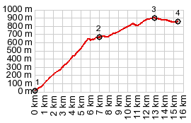
PARTIALLY PAVED / UNPAVED ( < jct 5110 - 59132 Krivi Put s(u) | 63058 Slivnica s(u) > ) Starigrad - Mirilia Road(ow) : Starigrad-Paklenica <> end of "Mirilia road" into Paklenica National Park : 22.9miles with 3800ft of climbing in 3:55hrs (garmin etrex30 r5:21.11.24) Notes: day also include hike up a nearby mtn from endpoint: h+b: 25.5miles with 4970ft of climbing in 5:2hrs. elev_max - elev_min = 3800ft-5ft. About the unpaved part: This was an ultra careful and slow roll on a touring bike over a mountain bike route. MTBs would take a fraction of the time.
|
|
|
advertisement |
|
|
advertisement |