| |
| |
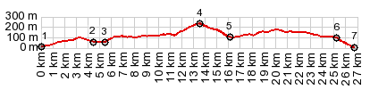
63058 Slivnica s(u) Parts of this little summit are a kind of viewing platform onto the Velebitski Bay in the Ariatic Sea. This looks small on the profile, but I think it delivers more scenery for each meter climbed, than any other Croatian road I know of. On pictures you could mistake this bay for a lake in the dolomites. But the villages and the barking dogs along the way correct that impression quickly.
After crossing the canal on an
impressive bridge, the turnoff to this minor
road with little traffic is marked as part
of a Mediterranean Bike Route. The Velebit
views get better and better. The town
Vijerac is a worthy scenic diversion, even
if it means more climbing. 63058 gets
noticeably steep on top for just a short
distance, passing through a typical village
of concrete houses.
From
West. (described downwards) .
Surprise - the land stretching to Zadar on
this side is largely forested. But the route
descends from the gentle ridge and picks up
the straight major highway again. After
climbing a little again, Velebit views are
just beyond the hedges and the barking dogs.
The profile descends to the village Razanak,
another incredible Velebitsky Kanal show off
- that's my opinion.
Dayride with this point
as highest summit
COMPLETELY PAVED ( < Starigrad Mirilia Road(ow) | D106 Pag - Novalja s(u)-1 > ) 63058 Slivnica s(u) x2: Starigrad > Rovanjska with detours > 63058 Slvinca s(u) > D106 west <> out and back to Razanak > D106 west > Rtina with out and back detours << turnaround short distance past bridge to Rab > D106 east > 63058 Slvinca s(u) <> out and back to first sign of Vinjerac >> Rovanjska > back to Starigrad: 664.5miles with 4240ft of climbing in 6:06hrs (garmin etrex30 r5:21.10.25) |
|
|
advertisement |
|
|
advertisement |