|
|
|
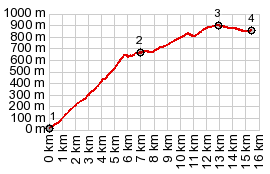
1.START-END SOUTH:turnoff from coastal
road in northern end of Starigrad
2.end of pavement
3.TOP, 2890ft~880m
4.end of double dirt track, a rocky trail continues
|
|
1.START-END SOUTH:turnoff from coastal
road in northern end of Starigrad
|