| |
|
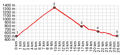
1.(00.0km,0500m) START-END WEST:turnoff
onto D44, just east of St Beat
2.(09.8km,1349m)TOP:Col de Mente
3.(16.7km,0790m)turnoff direction Le Chouteou, and
Portillon just after that
4.(20.8km,0640m)road to Col de Portet de Aspet stays
right; profile goes left
5.(25.7km,0510m)START-END EAST:lowpoint just south of
Bengouanet
|