| |
| |
Port de Bales
This is my favorite "home pass" of
what may be the most charming Tour de France town:
Bagneres de Bigorre. This route gets less traffic
than other passes near this attractive bath town.
Not only that, it climbs higher and is more remote
with better far views. Many maps do not show
clearly that this is a through going paved road
(including my bargain basement used Michelin
atlas).
The road passes a number of picturesque villages,
not particularly medievally clustered together,
but loosely organized around a church. Still - the
church sits on the highest spot of the village,
take Cabous for example. In Bourg d'Oeuil, the
road finally becomes serious - no more diversions
and excuses to stop to photograph village scenes
for me. It is finally time to get a work out in.
The road switches back onto itself and the rest of
the climb is on rounded tundra hills. On my ride
on the 29th of May it gets amazingly cold on this
last part. Behind Luchon a whilte lip of high
mountains appears that looks, still much colder
looking, than I feel approaching the summit. In
order to get a better look at them I take a short
out and back detour up the somewhat paved path to
Col de Pierrefite. On top of Port de Bales is a signforest, relating
to the pass, consisiting in equal measure of
warnings and dedications. The sticks stand out on
the tundra scape as do the hundreds of tiny sheep
dotting the green hills. 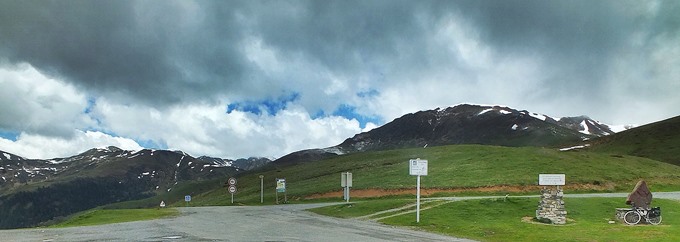
From North. (described
downwards) I imagine even in times when there are
no signs discouraging people from travelling over
the pass, this must be one of the more isolated
roads in the French Pyrenees. On the 17km between
the top and the first village Ferrere, I saw 2
cyclists and one motorized vehicle. If I would
have counted the turns instead, I imagine I would
have come up with hundreds - no switchbacks after
the very top, just and and neverending procession
of turns following a creek into ever lower depths.
The profile ends in Mauleaon-Barousse, another
village with small water falls and large flower
falls hanging above the water. Ivy overgrown walls
compete for attention with hanging balconies and
perfectlly placed flower pots.
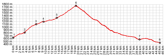
Dayride with this point as highest point: COMPLETELY PAVED ( < Port de Bonaiqua | Col de Mente > ) Port de Bales: Bagneres de Luchon <> short detour to Benque >> Bourg d'Oeuil > Port de Bales > Ferrere > Mauleon-Barousse > Cacarith > Siradan > Cierp-Gaud > Cier de Luchon > back to starting poinnt in Bagneres de Luchon with several sightseeing detours : 50.0miles with 5277ft of climbing in 5:19hrs (garmin etrex30 r5:19.5.29) 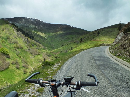 History HistoryCycling - Tour de France: The pass has been 5 times as part of the Tour de France: in 2007, 10, 12, 14 and 17. |
|
|
advertisement |
|
|
advertisement |