| |
| |
Col de Mel N116 manages a spectacular
crossing of a ridge in the Pyrenees, even if the
traffic sometimes is a little more than ideal.
Its highest point is the old Vobaun fort of
Mount Louis, very close to the named Col de la
Perche. But actually, there are several other
possible summit points in this area, all of them
a little higher, that allow an almost limitless
combination of loops, allowing to make whatever
part you choose from the Col de la Perche route,
part of your individual loop. Col de Mel is one
of these summit points. It is not marked on the
1:200 thousand road maps that I have, but there
is a small summit sign. This is an obscure summit in an area of other nearby better known passes. The approaches to all of them are pretty much interchangable. I think I picked one of the more attractive approaches to each side. The obvious road pass in this area is Col de la Perche. Other possibble summit points include: Eyne s(u), Col de la Llose, Col de la Quilane and others.
From West. Just before
the road heads back down to Mt Louis, there is a
small clearing with a good view of the opposing
range. Rather than following the west side down
the main approach to Col de la Perche, the profile
follows a recorded route that traverses along the
hills and villages on the slope to the north of
the main road. This is a much more pleasant bike
route, and crosses many separatey accessible
summit points, as well as one named pass, Col de
Fau, as shoulder point
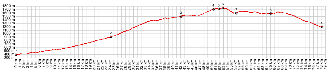
Dayride with this point as highest summit: COMPLETELY PAVED ( < Col de Puymorens | Collado de Ordino > ) Col del Mel , Eyne s(u) : Latour de Carol > Llivia > Gaillago > N116 east > Eyne s(u) > Col de la Perche via Mt Louis s(u) <> out and back down east side of Col de la Perche via Mt Louis on N116 with turnaround point at Fontpetreuse <> separte out and back from Mt Louis to just beyond too of Col de la Llose >> Col de la Quilane(shp) > D32f west > D32 south > Col del Mel > Route des Artiques east > Bolguelles > Col de Fau(shp) > Targasonne > Or > back to starting point in Latour de Carol: 64.4m with 6097ft of climbing in 6;25hrs (garmin etrex30 r5:19.5.14). |
|
|
advertisement |
|
|
advertisement |