| |
| |
Col de Puymorens
One of the main historical crossings
of the Pyrenees is still a very cyclable route.
This is the main road N20 between Puigcerda -
Spain on one side and Ax les Thermes - France on
the other. Andorra is also just a turnoff away.
During my crossing on a Monday traffic was
manageable, but the road to Andorra over Pas de la
Casa had been closed for weeks, because of an
earth slide. So my experience is probably not
representative. In any case, there is also a
peage-tunnel below the pass. So the several miles
over the top of the pass are always wonderful
cycling.
From below it looks like there is a small city on
top of the pass - built with fortification
strength walls. But when you reach the top, it
turns out to be not only abandoned, but also
vandalized.
From North. (described
downwards). The road rolls into high alpine
valleys. They look drier than the summit. While
still far above treeline the road to Pas de la
Casa to Andorra forks to the left. It is closed
when I pass by, Security guards watch that no foot
is set on pavement past the turnoff. There is another short alternative to parallel
the main road on an old highway, just a few kmm
before l'Hostitalet. It too was "barre".
L'Hostitalet is an historic stopping point for
pass travelers. An old railroad station and old
Inn buildings compete for attention. Unfortunately
the tunnel traffic emerges here too. From here
it's a fairly long descend through another
uniformly v shaped valley.
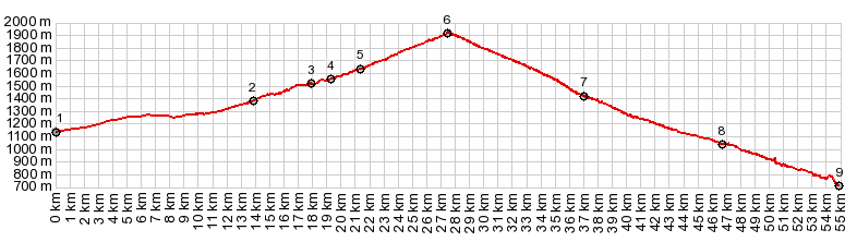
Dayride with this point as highest summit: COMPLETELY PAVED: ( < Plateau de Salinas s(u) | Col de Mel > ) Col de Puymorens x2: Latour de Carol <> Col de Puymorens <> l'Hospitalet <> Merens <> turnaround point several km below Merens: 50.7m with 5670ft 9.of climbing in 5:32hrs (garmin etrex30 r5:19.5.13) Notes: another strong Mistral day - coming back I was blown up the pass. History This pass marked the boundary between France and Spain until 1659. On that year the "treaty of the Pyrenees" gave the area with "villages north of the Pyrenees" to France. Exactly what "north of the Pyrenees" meant still had to be worked out. Also - the nearby French settlement Llivia was officially a villa and not a village, so it became part of Spain. The final product was renegotiated in the Treaty of Bayonne and today both the pass and the villa(ge) are part of France. In today's Europe without border crossing it is often very difficult to tell which country you are in. This is expecially true on the southern base of the pass around Llivia, Bourg-Madame and Puigcerda, where the border takes some confusing twists and turns. Cycling - Tour de France: This major road was on 6 Tour stages: in 1957, 64,65, 73, 76 and 93 |
|
|
advertisement |
|
|
advertisement |