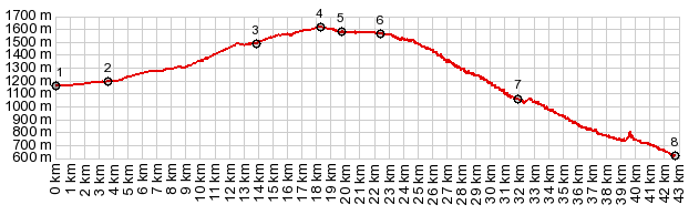
Col de la Perche is a fascinating bike ride over a major pass in the Pyrenees. Near the top is the fort Mont Louis, the highest point of the Maginot defense line. On the western approach to Col de la Perche you are pretty much committed to the main road and all its traffic. However, in the gentle hills on the east side there are several ways to get away from the often heavy traffic on N116 (even though it does have a fairly good shoulder). All of these alternate options climb a little higher, and so the summit point becomes something different than Col de la Perche. All of these alternatives also deliver different, and I think better views. The summit through the town Eyne lies on the south side of N116.
From East. A short
descent delivers some good views onto all the
other N116 alternatives, located up on the ridge
north of the main road. Then the profile rejoins
N116 right at the Col
de la Perche sign All the possible
summit points across the valley on the other ridge
are just slightly higher, so the profile goes down
the eastern approach of Col de la Perche.
A Dayride with this point as intermediate summit is on page: Col de Mel |