| |
| |
Col de Marie-Blanc This pass derives its fame from
3.5 particularly steep kms, that are often used
in the Tour de France. Otherwise this is a nice
forested, fairly unspectacular road, that is a
very pleasant ride, albeit very steep in places.
The meadow at the top is still 100m
or so below treeline. There is a very limited view
of the long green valley just ascended. A trail on
south side leads up go a grassy pass with nearby
peak with a good view direction Col d'Aubisque
and the cirque behind it.
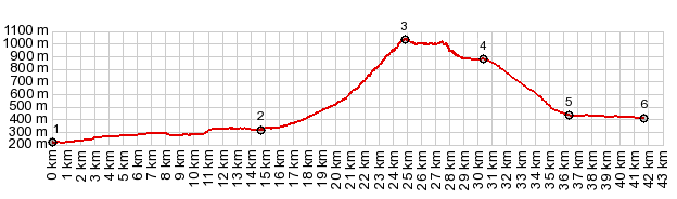
Dayride with this point as
highest summit COMPLETELY PAVED ( < Col de Somport | Col de St Pierre Martin > ) Col de Marie Blanc x2: Bedous <> Sarrance <> Escot <> Col Marie Blanc <> turnaround point at 880m: 30.7m with 3580ft of climbing in 3:35hrs (garmin etrex30 r5:22.09.13). Notes: Several hours more were spent during a hike from the pass up to the next pass and summit on the south side. 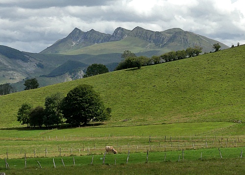 |
 From East. (also described
upards) This side is not nearly as steep, but more
scenic in my opinion. About 150m below the summit,
the road traveres a large meadow area full of
grazing animals of various species, surrounded by
mountains. This area has actually more appeal to
me than the summit. After that just a short climb
then leads to a last traverse in the forest to the
summit.
From East. (also described
upards) This side is not nearly as steep, but more
scenic in my opinion. About 150m below the summit,
the road traveres a large meadow area full of
grazing animals of various species, surrounded by
mountains. This area has actually more appeal to
me than the summit. After that just a short climb
then leads to a last traverse in the forest to the
summit.|
|
advertisement |
|
|
advertisement |