| |
| |
Puerto de Somport This is a major crossing between
France and Spain, and I didn't really know what
to expect. The other web pages I read, seemed to
be very contained in their enthusiasm. As for
me, this is one of my favorite Pyreneen
main-ridge road crossings. Admittedly, there are
not that many main-ridge road crossings. Many
more passes in the Pyrenees actually run
parallel to the main ridge line), I had great
weather, even better light. Traffic was not a
problem, and virtually non existent above the
tunnel. The 10 km over the top are spectacular
scenery-wise.
The road enters the green, lush
mountains and manages to stay at the bottom of the
valley, except for a minor hill or two. Bedous,
together with Accous and Lees-Atha sit in a
wide part of the valley with great views up the
"front range" peaks behind Aydus. These villages
taken together is the largest agglomeration of
people and also tourist oriented businesses along
the route. Probably about half of the route up
to the tunnel has a marked shoulder, that is well
usable for cycling. There are the customary narrow
canyon parts, one or two overhanging rock narrows,
and narrow village passages, where shoulders would
spoil the excitement. But often there really is
enough room, and traffic gets lighter further away
for Oloron.
There is a ski area on the French
side. But all of the summit buildings and the more
spectacularly located resort Candanchu are all on
the Spanish side. Not to be outdone by this a
short 2km spur leads to a higher French
ski-skyscraper type resort. There is also a short
foot trail on the west side of the pass that leads
to increasingly better vantage points onto the
mountain spectacle. Some of the pictures were
taken from this trail.
Past the junction with the tunnel, the road is wide and often has a shoulder to accomodate the different types of traffic. A markedly drier scenery, but still green and "in the trees" accompanies the rider on his way into Jaca.
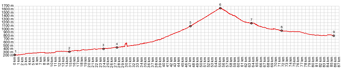
Dayride with this point as
highest summit COMPLETELY PAVED ( < Col de Bouesou | Col de Marie Blanc > ) Puerto de Somport x2: Bedous <> Puerto de Somport <> turaround point Villanua ~10miles before Jaca: 61.2miles with 6580ft of climbing in 6:40hrs (garmin etrex30 m5:22.09.09) |
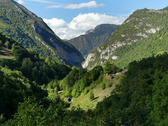 At the tunnel entrance it pretty
much disappears. There are a few quickly passing
views of jagged rocks between the trees. But it is
going to take another workout to get to the truly
unobstructed views. At that point the road is
amazingly wide, probably to accomodate the ski
traffic in the winter. The centerpiece,
approaching the summit, is a set of slupted
vertifcal cliffs, forming the northern crest of
this Pyreneen ridge line.
At the tunnel entrance it pretty
much disappears. There are a few quickly passing
views of jagged rocks between the trees. But it is
going to take another workout to get to the truly
unobstructed views. At that point the road is
amazingly wide, probably to accomodate the ski
traffic in the winter. The centerpiece,
approaching the summit, is a set of slupted
vertifcal cliffs, forming the northern crest of
this Pyreneen ridge line.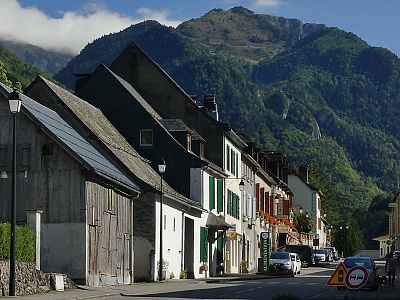 From South. (described
downwards). A wide three lane road bypasses
Candanchu (or you can go through it) and shows of
the center-altar of these mountains from a few
more sides. Just before the road meets up with the
tunnel traffic the road passes through an
interesting resort. It has a railroad station big
and ostentatious enough to serve a major
metropolis. Passing through the central part of
this tourist resort also gives the feeling of
going through a large urban development, between
rowhouses 4 or 5 stories tall.
From South. (described
downwards). A wide three lane road bypasses
Candanchu (or you can go through it) and shows of
the center-altar of these mountains from a few
more sides. Just before the road meets up with the
tunnel traffic the road passes through an
interesting resort. It has a railroad station big
and ostentatious enough to serve a major
metropolis. Passing through the central part of
this tourist resort also gives the feeling of
going through a large urban development, between
rowhouses 4 or 5 stories tall.|
|
advertisement |
|
|
advertisement |