| |
| |
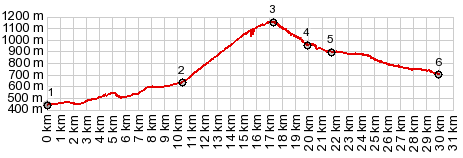
Passo del Predil The Jullian alps present a
very rugged picture - everywhere -
especially here on the Slovenian side. But
this road is probably always going to get
second billing to its famous neighbor Vrsic Pass.
Comparing Vrsic and Predil, there are not
as many varying high mountain scenes as
along Vrsic Pass, but more lakes. Near the
top of Predil is the junction with the
highest paved road in Slovenia: the out
and back climb to Cesta na
Mantgart(ow)
The village Log lies in a
great amphiteater of mountains. The road
will hardly try to climb to the top of that
topological cup. Instead the road climbs a
greener landscape with long switchbacks to
the west of this amphitheater. Later, slowly
the grade lets up and a number of green
saddles seem to present themselves as a way
to get across to Italy. Then all of a sudden
comes a sign Predel, accompanied by dramatic
bridge and a turnoff to a high one-way
summit : M
Mangart. But here "Predel" is not the
pass, but the name of the bridge and the
river below it.
But maybe this fort was far
ahead of its time. Especially in large
European cities, all kinds of structures are
erected to impede the flow of motorized
traffic and discourage the use of
automobiles, by making their use as
cumbersome as possible. This short stretch
of road, passing the sleeping lion, serves
this function very well. There is more about
the bloody history of this fortification in
the lower part of this page. A few more meanders are
necessary to reach a small pullout, from
where the mountains to the south present a
dramatic wall. The top is the border station
between Slovenia and Italy. From
North. (described downwards). This
side is benign on the brakes, compared to
the slopes of nearby Vrsic Pass.
Large radius curves reach through a tunnel,
so that the road seems to land along the
shore of Lake Predel like an airplane. The
lake glistens sliver in the late afternoon
light. But during morning, the mountains on
its end are dramatically lit. From here on
it helps to actually pedal, in order to
speed by the old mining town Cave del Predil
and back down to Tarvisio. Cave del Predil
has a small grocery and an intertesting
industrial look to the handful of streets,
gathering around the historic mining
operation.
A Dayride with this point
as intermediate summit is on page: Vrsic Pass
History When this pass was built, in 1319, it served as a trade route between lands of Austrian dominated heritage with lands of Italian dominated heritage. On the Italian side this was the town of Cividale and a patriarchate named Aquilela, and on the Austrian side the "duchy of Carintihia". The border ran right along the ridge crossed by Predil Pass. It may seem counterintuitive, that the lands with Austrian heritage were actually on the south side of the pass. But taking a giant step in history, both sides eventually become part of the Austro Hungarian empire and the importance as a trade route diminished. After the French revolution, Napoleon's troops were in this part of (what is now) Italy. The Austro-Hungarian emperor Franz 2nd, feared the unrest that Napoleon's revolutionary ideas could have on his multi ethnic empire, where no two ethnic groups were created equal. It was one of the few instances where Napoleon himself was attacked - by troops sent across Predil by Franz 2nd (officially named the "War of the Fifth Coalition" - but with so many European wars, who can really keep track of them all ? ). Things did not go well for the Austrian side in general, and a month later they were back on their way to Vienna, crossing Predel a second time. They took up defensive positions on top of the pass in order to cover the withdrawal of the rest of the troops. The fort near the top, which causes these surrealistic traffic jams today, was just a construction of wooden barricades. The Austrians were badly outnumbered in this conflict. The commander refused all offers of surrender for him and his Croation troops, and so they all died after the long "battle of Predil". This is the kind of thing that needs to be officialy honored, so that the next generation of soldiers will "recognize the bravery of it all", and the result is today's stone fortress and the artistically beautiful depiction of a sleeping lion, in immediate vicintiy of today's occasional traffic jam. Franz 2nd and Napoleon had a different idea on how to settle their hostilities. Napoleon married Franz's daughter. Skipping forward any number of European conflicts, Slovenia became Slovenia in 1945, formerly part of Yugoslavia. It did not become an actual country until 1991. For a long time it was the one truly spectacular alpine vacation destination, that citizens of the European east block countries under Soviet rule, could visit. |
 During the last
few gentle meanders through the slightly
sloping forest, the road goes right through
the middle of what looks like an old
fortification. While inside of it, for 20
meters or so, the road narrows in order to
lead by a sculpture of a reposing lion, with
inscription of a war engineer. I had
encountered barely any traffic on the
(relatively) wide road on the way up. But
during those 20 narrow meters a bus came the
opposite direction. In order for it to be
able pass through, I had to turn my bicycle
around and wait at the entrance. This is the
kind of thing I sometimes dream and then
wake up, thinking: that's bizarre and so
unrealistic.
During the last
few gentle meanders through the slightly
sloping forest, the road goes right through
the middle of what looks like an old
fortification. While inside of it, for 20
meters or so, the road narrows in order to
lead by a sculpture of a reposing lion, with
inscription of a war engineer. I had
encountered barely any traffic on the
(relatively) wide road on the way up. But
during those 20 narrow meters a bus came the
opposite direction. In order for it to be
able pass through, I had to turn my bicycle
around and wait at the entrance. This is the
kind of thing I sometimes dream and then
wake up, thinking: that's bizarre and so
unrealistic.|
|
advertisement |
|
|
advertisement |