|
|
|
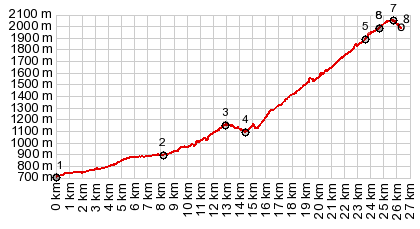
1.START-END NORTH:low point in Tarvisio,
on river Gallitz direction Fusine
2.Cave del Predil
3.Passo del Predil, 1156m
4.turnoff to road up M Montgart on left
5.closed to cars (temporary?) from here on
6.start of one way loop at top
7.TOP, 2050m
8.same as point 6, end of one way loop
|