| |
| |
Col de Lancon
Generally I am excited, when I can
report the fact, that I have met a lot of other
cyclists going over a particular summit. That is
especially true about the area where I live,
because that is something special, and it does not
happen all that often. Well - in this part of the
Pyrenees in June, there are so many racers on
bikes out there on the road, the special exception
is actually, when few bikers ride over a summit.
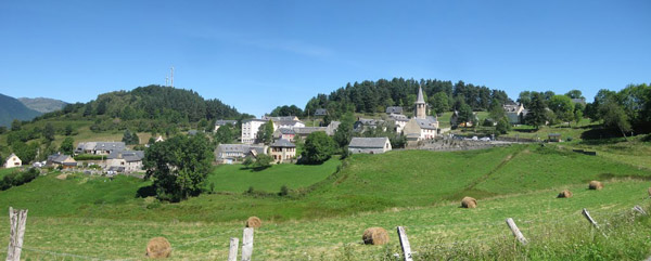
This pass falls into the latter category. Granted
- there are no superspectacular views along the
way. But there is a practically deserted old town
on the edge of a mountain, grouped in perfect
harmony around the massive walls of a small
church, that despite its small size, still manages
to dominate the town picture in every way. At the
highest point of the road is a single metal cross,
which makes a perfect picnic site. Actually - I
enjoyed this little summit more than some Tour de
France passes. Oh - I should mention, on the way
down I did see two other cyclists, a couple on
touring bikes who seemed to be enjoying themselves
very much.
Ilhan turns out to be just a house at a turn in
the road further up the hill. A little later the
first mountain view appears behind, and the Ilhan
house is the foreground. Curving around the north
end of this little ridge, the road levels out and
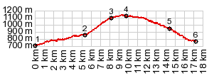
enters open high fields. The road reaches a
clearly defined high point, at a metal cross
before entering the town of Lancon. The church
here makes a great foreground to whatever you want
to place behind it in the photograph.
From South. (described
downwards) There are at least two ways down on
this side. A northerly route goes directly back to
Arreau. I took the southern option. It passes a
picturesque walled in cemetery at the edge of the
forest. Then a long traverse through the woods
leads down to Gouaux. It's still a couple of km on
the numerous valley roads between not-so-small
villages in this wide bottomed valley, to find a
low point at a bridge over the river Aure. Dayrides with this point as intermediate
summit are on pages:
|
|
|
advertisement |
|
|
advertisement |