| |
| |
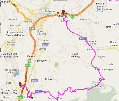
Jochgrimm
aka pso. di Oclini Jochgrimm is a pass over a good
dirt path that offers escape from heavy holiday
summer traffic, at least on the final approaches.
photo
page
From South. Riding to the top of
Jochgrimm on the most direct way on a holiday can
range from very peaceful to holiday traffic
stress, depending on the interval. Aproaching Auer
on the wineroad between Trento and Bozen is
accomplished via the best bicycle trail in the
world. But you have to leave it in Auer. A glimpse
up the hillsside shows what's ahead. A shelf road
high up on the limestone cliff that appears to be
held in place by superglue. On Sundays in spring
just follow all the racing bicycles. The route is
signed as val di Fassa and traffic can be
overwhelming on holidays. The switchback on the
shelfroad is such a popular stopping point it
feels like a motorcycle party. All the racing
cyclists just keep on going. Once the hanging
valley is entered, slope and traffic seems a
little more relaxing again. But the way to finally
say goodbye to all the german motorcycle caravans
is to take a left to Radeln. The grade picks up
again and the thick verdant forest continues all
the way up to the town of Radeln. During end of
may, snow covered high peaks show through in the
clearing. Shortly before entering the town of
Radeln, a sign with accompanying map point the way
to the right up a fairly smooth surfaced dirt
track to Jochgrimm. The only other traffic on this
track are "Ermaechtigte" or "the authorized ones",
which is generally only the occasional local
farming tractor. After a thousand feet further
climbing in the forest, a mountain above treeline
finally comes in sight, the Schwarzhorn (or Black
Horn). From this side, its partially green slopes
it has a much more southern appearance than the
wall like peaks to the north. But this mountain
also has a rugged northern face. The trail passes
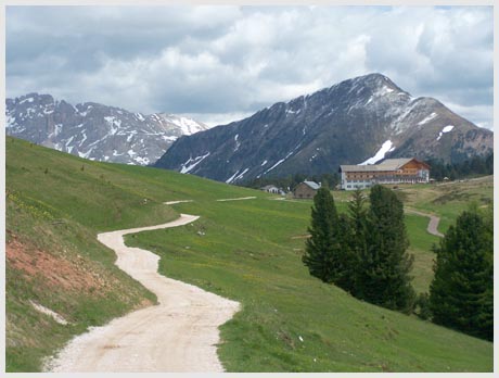
past a large alpine hotel of sorts and then heads
for a gap between the Schwarzhorn and Weisshorn
(White Horn). This is where needle like mountains
of the dolomites come into sight. At the summit
are a large hotel, a restaurant, on holidays
busloads of tourists, and at least one single
track trail that takes off below a ski lift.
From North. (described downwards). The
long 6000ft roll back down meets up with more and
more traffic at each junction down into Bozen.
First it's a couple of peaceful kms more down to
the hotel at pso Lavace. Turning left leads over
the Lavace summit after a couple of hundred
meters, and then rolls down in forested
serpentines to the junction with Karerpass. At the
junction with the Karerpass road is a great view
back to the mountain you just came from, possibly
more impressive than the view of the same peak
from the top. Karerpass can have heavy traffic and
means the return of the dreaded endless german
motorcycle caravans. There are many tunnels,
including a 1200m one, followed by a 1550m one.
But a detour is possible. See the Karerpass page,
or the Nigerpass page. First picture shows the ascent from Auer into the
val di Fassa. Second picture taken approaching
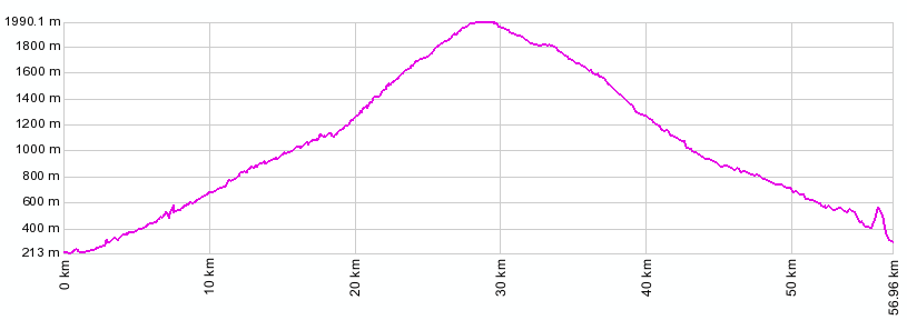
Jochgrimm top. Jochgrimm: Andrian > Bozen >Auer > Kaltenbrunn > Radeln >Jochgrimm -> pso. di Lavace(shp) > Eggental > Bozen > Andrian: 64 miles with 6300ft of climbing in 5:4 hours, Notes: did not get lost or ride extra shopping miles. (VDO MC1.0 m4:9.6.1). The last day on this Extended Tour with different start and end points, ending in Andrian, was over: Penser Joch
|
|||||||||||||||||||||||||||||||||||||||||||||
 Approaches
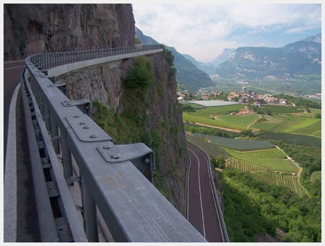
|
|
advertisement |
|
|
advertisement |