| |
| |
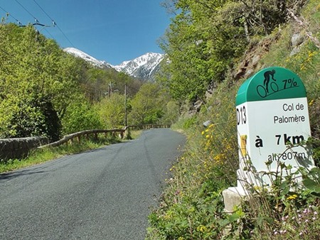
Col de Palomere
This is the highest paved two way
pass, between the Mediterranean Sea and the first
real peak of the Eastern Pyrenees: Massif di
Canigou. The pass does not quite reach treeline.
Mostly this is a ride along oh-so-curvy peaceful
roads. I saw maybe one or two dozen cars, and
twice the number of cyclists on a weekday in early
May.
Slowly the peaks make an appearance. Just past
Valmanya the road suddenly pulls away from the Pic
du Canigou (which the road has been heading for
now), and contours along a small descent to the
east, and then heads for a low gap at just below
treeline. There is sign here, maybe a couple of
parked cars, and tracks that head along the gentle
ridgeline in both directions. A short walk to the
round mountain to the east improves the view of
the Canigou massif quite a bit.
The road winds down through the trees in endless
peaceful turns, without hardly a car encountered
and then climbs almost imperceptively to Col
Xatard. It's less than a 100 meter climb, so I do
not count it as a crossed pass in the ride below.
The profile could continue either way downhill. In
order to demonstrate my dayride it goes left, past
another medieval church to another gentle pass in
the forest, Col de Fourfou, again just a shoulder
point on the way down. Returning towards the starting point I stay left
here and continue the gentle descend through
rolling scrub forest mountains, with the
occasional medieval chapel lurking in the valley
below. Bouletenere provides one more chance to
cool off in medieval narrow street canyons around
an old church before the traffic of N116 subdues
the senses into traffic automatism..
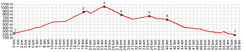
Dayride with this point as highest summit: COMPLETELY PAVED ( < Colle Mollo s(u) | Col de Jau > ) Col de Palmorere: Rodes > Vinca with short detours > Bailestavy > Valmanya > Col de Palomere > la Bastide > Col Xatard(shp, 752m) > Brunet et Belpuig > Col Fourtou(shp) > Bobleternere > Col de Terneve (shp,232m) > back to starting point in Rodes: 42.7m with 3883ft of climbing in 4:26hrs (garmin etrex30 r5:19.5.6). Notes: a perfectly sunny and clear day after a perfectly sunny and clear day with winds that blow away bicycles. - Another broken spoke, but quick fix with last replacement spoke that I have with me. |
 From South. (described
downwards) If you are looking for a 10th century
chateau to buy there is one available in the next
little medieval cluster of houses on the way down,
called La Bastide. For me it is just a superb
picnic site: a bench in a deserted square around a
tortured looking tree, pruned into knots. The
clock on the chateau tower reads 9:45, trying to
convince me that I am definitely not late, no
matter how many baquettes with brie I have for
lunch.
From South. (described
downwards) If you are looking for a 10th century
chateau to buy there is one available in the next
little medieval cluster of houses on the way down,
called La Bastide. For me it is just a superb
picnic site: a bench in a deserted square around a
tortured looking tree, pruned into knots. The
clock on the chateau tower reads 9:45, trying to
convince me that I am definitely not late, no
matter how many baquettes with brie I have for
lunch.|
|
advertisement |
|
|
advertisement |