|
|
|
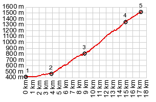
1.(00.0km,0420m)START-END WEST:Voi Verte
de Gaves, east of Argeles-Gazost
2.(03.9km,0460m)profile turns onto road to Hautacam from
D13
3.(08.8km,0810m)Artalens-Souin
4.(14.9km,1340m)first signed top: ski area parking lot
5.(17.3km,1520m)TOP:end of pavement at Tramissal kiosk
|