| |
|
|
|
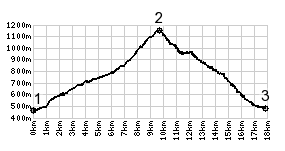
1.(450m,km00.0) START-END
NORTH: south of Talloires, on shore of Lac D'Annecy
2.(1157m,km09.7)TOP: Col de la Forclaz
3.(480m,17.6km)START-END SOUTH: jct D402-D1508 and
Piste Cyclabile along Lac d'Annecy, north of Giez
|
|