| |
| |
Dubce Pass This is actually a really
low pass with a very small, not even steep
climb. However - pictures can make it look
like the road below is chiselled into a
cliff. Also the limestone peaks of the
Dinarian mountains to the south reach 1700
meters. This is definitely a favorite
coastal location for me ?
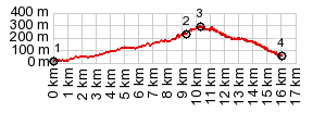
At a high point on this coastal traverse at about 250m, a turnoff leads to this pass. Two moderate switchbacks quickly lead to the top. A road cut is directly before the pass. Here the last view of the sea disappears forever, but the rugged peaks above Makarska will still keep the rider company for a long time.
Staying on the main road to
Zadvarje, it is more difficult to find an
approach of any height. The road only looses
about 100 meters to a low point past
Zadvarje before it starts climbing again.
However there are various descends into deep
river canyons that one could interpret as
another approach on this side. Sidetrip to an old
microwave reflection dish above the pass The views I was able
to get from this small out and back summit
are my favorite memories of the Dinarian
mountains behind Makarska.
Dayride with this point
as highest summit:
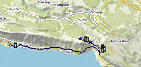
PARTIALLY PAVED / UNPAVED ( < 6142 Tugare(sh) | same page > ) Dubce Pass , D70 Gata(sh) , 6167 Logva Rogoznica s(u) : Omis > 6167 east > 6167 Logva Rogoznica s(u) <> out and back to end of road above Logva(ow) >> 6167 east > Dubce Pass <> out and back to end of road in Matesani >> 6167 east[unpaved] > Dubce Pass > Zadvarje > Sestanovac <> out and back on 6171 to Kresevo >> D70 Gata(sh) > back to starting point in Omis: 51.1miles with 4590ft of climbing in 5:18 hrs (garmin etrex30 r5:21.11.15). ( < same page | Sveti Jure(ow) > ) Dubce Pass , 6166 Smoline(sh) , addtional out and back : Omis > 6166 east > up Cetina Canyon > 6166 Smoline(sh) <> out and back to Svinisce and other small villages > Kucuce with detours > Slime > Dubce Pass <> out and back partly up out+back summit with microwave relay facility >> D8 west back to starting point in Omis with detours: 40.5 miles with 3910ft of climbing in 4:30hrs (garmin etrex30 r5_21.11.16) |
 From South. (described
downwards) Two inland approaches meet
exactly at the top. Taking a left onto the
small 6137 parallels the above described
northern approach in a deep river canyon
back to Omis. That is the option shown on
the profile.
From South. (described
downwards) Two inland approaches meet
exactly at the top. Taking a left onto the
small 6137 parallels the above described
northern approach in a deep river canyon
back to Omis. That is the option shown on
the profile.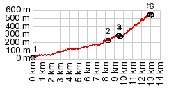
|
|
advertisement |
|
|
advertisement |