| |
| |
Sveti Jure(ow) This is a very special group
of mountains. They are made of limestone,
which is extremely prone to forming large,
precipitous cliffs. It forms difficult to
traverse karst topography of sharp craggy
rocks. This a very special set of
limestone mountains. They adjoin the
Adriatic sea, rising over 1700 meters
above it, the highest coastal range in Croatia.
This road leads to one of its highest
peaks, St George Mountain. It is also the
highest road in all of Croatia, and
therefore I don't need to say that it's
special again. Sorry - I just did.
All of this is enclosed in the Biokovo
Natural area. So, generally you pay for
access and commercial development is
controlled.
This scenic traverse finally
ends on D512. To get to the road to Sveti
Jure you have to turn right, not left as my
Hravatska Atlas clearly shows. There is
usually an entrance fee collected at the
turnoff to the out and back road to the
peak. I remember this climb in three
sections. The first one consists of
switchbacks climbing above the Adriatic.
Dead trees make the foreground to a blue sea
from above. The early switchbacks become
smaller and smaller, until they disappear
below. Now the road enters a forest, and a
few choice views at exposed switchbacks are
separated by extended forest workouts. The road reaches a kind of
edge on the plateau. Signs advertise a
"skywalk", a kind of glass floor walkway
that reaches out over the cliff. Even though
it is closed and barricaded, it inspires
motoryclists and cars to stop in respectable
numbers and talk loudly about things I
cannot understand. This is the largest group
of people I saw along the way. This may also
be the last stunning views of the sea, and
definitely the last views (till the return)
of the the two gigantic steps, the mountains
make, to descend into the Adriatic
vertically. 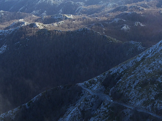 Section Number 2 of this climb
is a kind of rolling plateau ramble in this
karst range. It is amazing to observe just
how difficult this terrain of jagged rocks
is to traverse, by taking a few steps next
to the road, and observe all the sharp edges
cutting into shoes and clothing. Then - just
ahead a cairn seems to show up on a small
hill. Can that be the top already? Actually
yes, but it is not as small as it appears,
and it is not even a cairn - but a
transmission tower sitting on a cone shaped
mountain. The road circuitously aims for
this general goal with a million small turns
and dips. It is the perfect cycling road,
even if very rough for regular skinny tires.
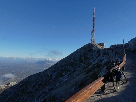
At the top the gated
transmission tower blocks the view to the
east. But a walkway leads around a fence to
a great view point at a small church. In
that direction several vertical faced
mountains show the most interesting area
(along with Sveti Jure) of the Biokovo
Natural area. I made the top cycling
elevation a little lower than what is
usually specified for Sveti Jure, because
the top of the mountain with the
transmission tower is not publicly
accessible. Slideshow of the section
starting at the park road to the summit:
( < Dubce Pass
| Kozica Pass
> )
D8 Igrane s(u) x2 : Zivigosce Camp Sela <> Mala Duba <> Milagrane <> D8 Igrane s(u) <> Podgora <> Sveti Jure(ow)
|
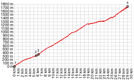
 Now it is time
for the last phase of the climb: a traverse
in the limestone, the edge marked off with
tall snow poles marks the transition: Past
that six regular ramps, connected with tight
switchbacks lead up the backside of Saint
George Mountain. During clear weather I
think there are more great views all the way
to the Adriatic. But more often, shreds of
clouds form ever changing patterns on the
pitted bowls of the mountains and obscure
the sea. The shape of these mountains here
seems to mimic its own erosional patterns: a
cascade of pitted craters
Now it is time
for the last phase of the climb: a traverse
in the limestone, the edge marked off with
tall snow poles marks the transition: Past
that six regular ramps, connected with tight
switchbacks lead up the backside of Saint
George Mountain. During clear weather I
think there are more great views all the way
to the Adriatic. But more often, shreds of
clouds form ever changing patterns on the
pitted bowls of the mountains and obscure
the sea. The shape of these mountains here
seems to mimic its own erosional patterns: a
cascade of pitted craters|
|
advertisement |
|
|
advertisement |