| |
| |
6142 Tugare(sh) Finding good cycling routes,
while visiting cities, often takes a
little longer, because of the need to get
away from traffic. This is a great cycling
route between Split and Omis. It follows a
high valley with a single ridge separating
it from the Adriatic Sea. But the high
point of this trip is surely the out and
back segment to a small 10th century
church up on that ridge.
The profile follows the first turnoff from D70, signed as going to Split. The road now follows a small linear valley with the Mediterranean hidden behind a ridge. A turnoff at the top can solve that visibility problem. This two-way top is located at the main intersection in the small village Tugare. From
West. (described downwards)
This side is gentler. A speedy decent on a
patched up road through patched up villages
leads to the Strobrec on the outskirts of
Split. A large variety of construction
debris lines the road. 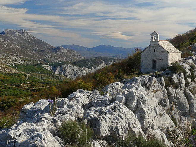
Sidetrip to the
Transmission Relay station above Tugare:
Later I met a British mountain
biker who carried his bike to this church,
on a trail directly from Omis, then went
down this way.
Slideshow
of the Sidetrip to the ridge, and short walk
to the church
Dayride with this point
as highest summit:
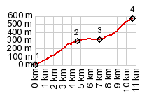
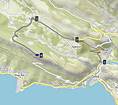
COMPLETELY PAVED ( < Clis Castle(sh) | Dubce Pass > ) 6142 Tugare(sh), 6270 Kucine(sh) , additonal out and back : Stobrec > D8 south > Dugi Rat > Omis > up D70 > 6142 Tugare(sh) <> out and back to transmission tower above Tugare(ow) >> closed loop above Smovnica with less than 500ft top elevattion, but more than 300ft of climbing >> up6270 > 6270 Kucine(sh) > Split with many miles of sightseeing detours > back to Tugare with sightseeing detours: 49.6miles with 3880ft of climbing in 5:05hrs (garmin etrex30 r5:21.11.12) Notes: day also included a short walk to the church along the one way summit, as well as much sightseeing around Split. |

|
|
advertisement |
|
|
advertisement |