|
|||||||||||||||||
|
|
|||||||||||||||||
| |
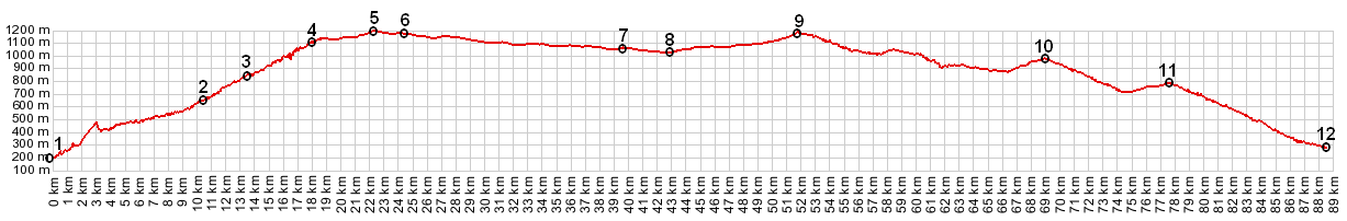
D2 Clues de Greolieres - Plan du Peyron(sh)
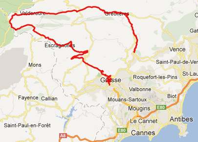
The ride through the valley gorge of Greolieres can be part
of the approach of Col de Bleine
, Col de Castellaras,
(or sevaral other passes), but it doesn't have to be. You
can also ride any of these three without any of the other
two on this dense network of small, superbly paved roads.
The route over just this summit point is located on a
shoulder of the other two (ie. you don't drop more than
300ft or ~100m) to keep climbing to the higher points. It is
fairly difficult to make this point the highest point on a
loop ride. The profile below is about the only option I can
find, and even then it goes over another point, whose
altitude is within the margin of error.
picture page
From East. To give this profile a resepectable
elevation difference, I started it in Gorge du Loop. I did not
ride that part. I came onto the route at point 2, after
descending Col du Vence. I spent
the night in Greolieres and then discovered the picturesque
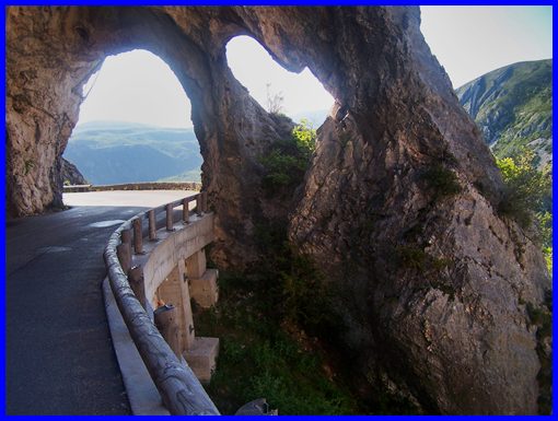
route with the birds eye view of Greolieres and Cipieres in the
new light of the next sunny morning. Between here and the summit
the road goes through 3 short tunnels. After coming up from the
busy coast this really was another world, removed from all the
traffic and frantic noise. At the top of the plateau the route
turns away from the gorge and enters a high forested plateau,
the Plan du Peyron. Hard to tell exactly where the highest point
is while on the bike. But according to the map, it is just
before a modern billboard advertising in graphic detail the
mountain biking and skiing possibilities in Greolieres Les
Neiges. The turnoff on the right to the out and back climb
follows immediately afterwards. Looking to the left as the road
turns away from the gorge, you can also make out the hill of
another ski area at l'Audibergue. The turnoff point to Col
de Bleine and Col de
Castellaras is nearly as high as the summit.
From West (described downwards). The
descend through Valderroure on a pleasant forested, straight
road is so gradual you hardly notice it. In order to continue
downhill the profile proceeds through Seranon, Escragnolles,
Saint Vallier de Theiy to Gras. My own route stayed on the
plateau a little longer, and crossed another small unnamed
summit on D452 direction Castellane. Extended Tour: (<Col du Vence|D452 Peyroules(sh)>, Col de Luens>) D452 Peyroules(sh), D2 Clue de Greoliere(sh), Col de Luens: Greolieres > D2 Clue de Greolieres/Plan du Peyron(sh) > Valderoure > D452 Peyroules s(u)-(sh) > route du Napoleon > col de Luens > Castellane <> maybe 15 miles of out and backs around Castellane: 51 miles with 3368ft of climbing in 4:46hours. (VDO MC1.0 m4:12.5.17) This includes about 15 miles of out and backs around Castellane. A Dayride with the same starting location (Greolieres) is on page: Col de Bleine back to Cycling Passes in Europe
|
 Approaches