| |
| |
Clis Castle(sh) Picture a city inside of a
large natural amphiteater - that's
Split The top of this bowl is lined
with a modern four lane highway, built to
handle post communist modernity - and all
of its traffic. But there are several
small roads that lead up to the rim of
this big scenic cup, these two amongst
them. Although - finding and exploring
this area for the first time will probably
involve more traffic than subsequent, more
informed ventures. The upper parts of this
bowl consists are an amazing mix of small
alleys, below an old castle perched on top
of a mountain. ... Kind of. These are
several shoulder summits possible in this
area. The real actual highest points, the
road summits - are just a bit higher on an
rolling plain. But up there it's so
comparatively flat. So it 's hard to tell
exactly where they are.
From
East. (described downwards). The
critical part to roughly going down this way
(instead of one of the approaches above) is
to turn off the main road 6253 at an
unsigned intersection. There is no sign,
except for one that forbids a left turn onto
it, when coming down 6253. This is exactly
what you have to do - and the sign
forgidding it, is best way to recognize that
you have to do it. It soon becomes clear that
this is actually the signed road bike route
100, even if further up there is no
indication of this. The signs along the
route down here are still very confusing.
After crossing a marvelous viaduct in the
midst of other bridges of wildly different
types, a sign clearly shows to turn off
left. The route swoops down under the just
crossed viaduct, in order to dead end in a
neighborhood with death defying dropoffs
beyond the porches, crowded with playing
children and cars attempting to turn 180
degrees, as if on a turntable for
locomotives. The profile does not take this
erroneous turnoff, but just goes straight on
this scenic traverse above Split with ever
improving views (at least if it's late
because of the light) onto the castle and
its village.
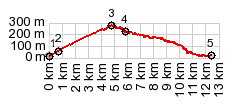
Dayride with this point
as highest summit
COMPLETELY PAVED ( < D106 Pag - Novalja s(u) | 6142 Tugare(sh) > ) Clis Castle(sh) , Telegrin s(u): Strobrec > Split with detours along coast > Sustipan > Telegrin s(u) > 639 clockwise along coast or parallel > Solin > D8 west > Kastela > 6137 east > Solin > 6253 north > Klis Castle(sh) > 67074 west > 6253 north again for short distance > down 67075 with detours > Split with many unsigned dead end detours in industrial areas > back to starting point in Strobrec: 56.0miles with 4480ft of climbing in 5:44hrs (garmin etrex30 r5:21.11.11) 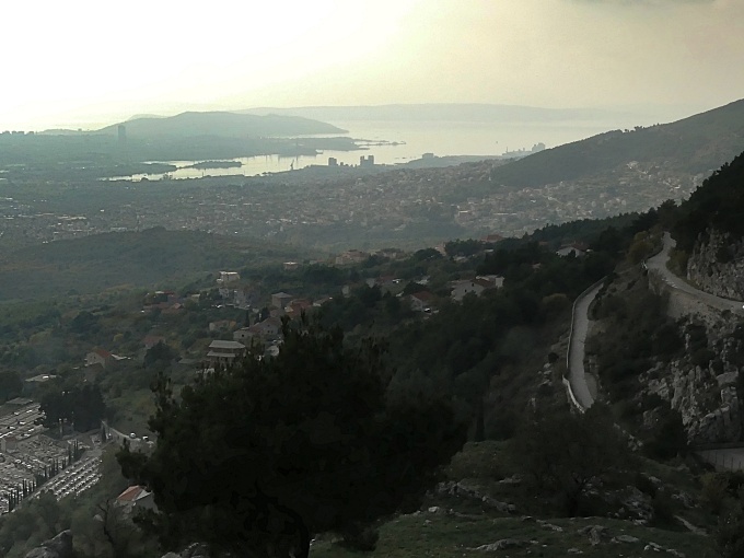 |
|
|
advertisement |
|
|
advertisement |