| |
|
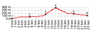
1.(00.0km,020m)START-END EAST: jct RmD14-RdD15, west of Aguilas
2.(05.4km,070m)start of narrow agricultural road in El Pozico
3.(10.2km,160m)profile joins larger road Rm20
4.(13.9km,380m)TOP: trailhead at highest elevation
5.(18.7km,180m)profile turns right on Rm-332
6.(22.7km,120m)START-END WEST: low point on R-332, some kms east of Mazarron
|