Puerto de Cabezo de la
Plata
Here is another ridge crossing that
looked interesting on the map, and even more spell
binding in reality. Not only is the dessert
scenery fascinating, but it is actually a very
popular cycling goal. I must have seen about 100
bikers on this road. - Don't remember any cars
over the top.
| I have used the pictures of
panoramio and flickr contributors, as well
as other web sites to illustrate this page.
There are copyright notices and links
to all original pictures. My own pictures
were on a computer, that was stolen at the
train station Frankfurt Airport (model Acer
Aspire One (serial# NUSGPAA01625101C947600F) |
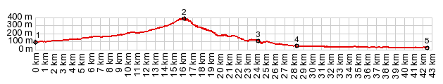 |
1.(00.0km,100m)START-END
SOUTH: Rm-F20, just west of Biasicas
2.(16.3km,380m)TOP
3.(24.2km,100m)settlement: Cabezo de la
Plata
4.(28.4km,050m)START-END NORTH: profile
turns west and traverses, slightly above
the valley of the Orihuela
5.(42.6km,020m)START-END NORTH ALT:
Orihuela
|
 Approaches Approaches
From South. The profile
starts outside of Biasicas and its straight white
rows of apartment blocks. The goal is the obvious
gap in the low, straight rock ridge directly to
the north. The road gets interesting after
crossing the railroad tracks northeast of Sucina.
Since cars can get across this little desert ridge
much faster on nearby Rm-1, there is virtually no
traffic. A "rustic" road surface further
discourages fast motor vehicles.
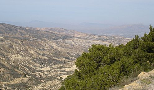
During the climb a nice view of the many
settlements, dotting the coastal plain, receding
to Cartagena and the Mediteranean in the haze
opens up below. Just before the highest point
there is a trailhead and a sign showing the
various tracks through this fascinating dessert
ridge.
From North. All the
interesting dessert views are on this side. The
trees open like a curtain onto a stage, featuring
very recent geological deposits. The road follows
the features of the dessert closely, resulting in
many turns and many a crossed barranco. Nearing
the end of the rol,l the road junctions become
very confusing for bicycle travelers. A few
connections are closed to bicycles, another
unsigned road ends at a farmhouse, and in my case
a bike path is flooded with deep mud. Finally I
take a road, that traverses ever so slightly above
the valley carved by the river Orihuela heading
west. Behind it to the north is the Sierra
Orihuela. It does not look like much on the map,
but sometimes reality is different - an extremely
steep dessert wall, that ends abruptly in the
vacation town Orihuela. It is the most impressive
environment, that I have visited in Murcia.
Amazingly the river is here only 20 meters above
sealevel, but still many kms from the sea.
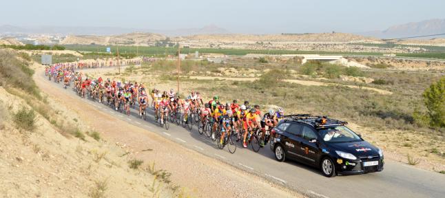
Raceday on Cabezo de la Plata
Copyright:
laopiniondemurcia.es pagelink
A Day on a Tour with this point as
highest summit:
( < Cabo Cope
s(u) | Portell de
Cati > )
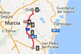
Puerto Cabezo de la Plata : Cartagena
> Torre-Pacheco > Baisicas > Puerto
Cabezo de la Plata > El Mojon > Orihuela
with detours > Albatera.
Notes: gps data is on stolen computer
|
|
| cLiCk on image , arrows ,
or thumbnails to advance slideshow |
|