| |
| |
Brenner Pass
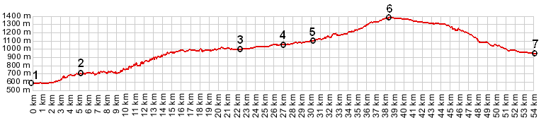
Nowhere else can you cross the
central alps at an altitude this low. No surprise
then that this gap between the Stubaier alps and
the Zillertaler alps has been a busy crossing
since before Roman times. In spite of the fact
that this pass is usually only mentioned as
cycling possibility, when the other higher passes
are closed, this is an attractive cycling route.
Traffic can be moderately heavy on this road, but
most of the auto traffic utilizes a newer 4 lane
highway.
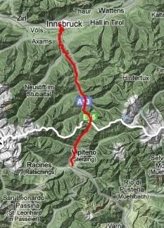
From North. On an extended
tour the nicest way to ride into Innsbruck is on
the bike road (it's wider than a path) along the
south side of the river Inn. Once in the
university area of Innsbruck ( easy to tell for
obvious reasons, but there is also a university
bridge ) you have to make your way through the
city center to pick up the Brenner road heading
south into the mountains. A modern 4 line highway
takes the high route, often on stilts, and with
wild bridge constructions. Cyclists can utilize
the old route 182, passing through all the towns.
During spring there is moderately heavy traffic on
this road, including a lot of cyclists. One can
only imagine if all the trucks loaded on trains,
that can be seen speeding up the pass on tracks,
would be driven instead. The slope is pretty
moderate as alp passes go, except for one short
stretch past Steinach where the old road decides
to catch up in altitude to the new highway. Near
the top a few enticing views up side valleys like
the Valsertal hint at mountains that are much less
gentle than this crossing. At the top on the
Italian side, the town of Brenner has a sort of
leftover border town feeling to it, outlet stores,
bargain stores etc., even though the border has
not been manned for many years. The top also has a
large rail station, where some cyclists get out of
the train in order to ride the Brenner Pass
downhill only.
From South. (described
downwards). This side is gentler. But looking up
the Pfirschtal from Gossensass (Colle Isarco) to
the 3000m ridge above imparts a different
impression. Near the bottom, the town of Sterzing
has an old tower around which an attractive old
tourist city center, comprised of one single road,
stretches south.
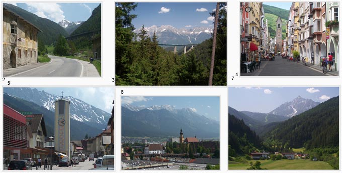
picture locations: 4:
Sterzing, 6: Innsbruck, 5: town of Brennero;
1,2,3,7: Austrian side of Brenner Pass History Prehistoric times to the Romans: Evidence of men crossing Brenner Pass goes back to the early Bronze age. Of course the Romans also used the pass. But it was not a principal artery like nearby Reschenpass, so that it was not built into a formal road until the 4th century. The name "Brenner" traces back to the mineral "Bernstein", which was an important trading good, carried over the pass. During the Middle ages, rulers continued to profit from the roads built by the Roman. The most difficult passage along the way was the gorge of the River Eisack between Bolzano and Waldbruck. During this time much of the road through here became impassable and a detour over the high plateau outside of Bolzano was required. The pass road was picked up again just south of Brixen. The first attempt to fix up this portion of the road was made in 1314 by a tradesman from Bolzano. When that was not a permanent solution, further attempts were launched by Tirolean rulers in 1481, making it a toll road. Railroads: In 1857 the first railroad connected Austria with Italy. It was the Semmering railroad from Vienna to Triest. Due to the high traffic a second railroad was started in 1901, the Tauern railroad. This second railroad involved an 8.5km two track tunnel reaching 1567 meters inside the tunnel. Compared with that, laying tracks over Brenner Pass was an easier option. But it didnd't happen until later in 1867, and now the old German Haseatic cities had a rail connection to Italian harbours. Unlike the Swiss alpine traffic, most of the volume travels the road, rather than the rails. To shift more traffic to the rails, a 55km long Brenner Basis tunnel is planned, which will emerge on the Italian side near Franzensfeste, and old military fort and munitions storage facility. Modern Roads: The four lane express road, which runs much higher up the valley on the Austrian side, was finished in 1974. The last portion to be completed was the Italian portion between Bolzano and Chiusa. But the most impressive road engineering project along the way is the Europa Bridge (picture 3 above), built between 1960 and 63. It is the second highest bridge in Europe. Under low traffic conditions ( I was going to say "normal traffic conditions", but that may be the wrong word these days ) this makes for a an hour and a half drive for what takes the cyclist a day. A Day on a Tour:
|
|||||||||||||||||||||||||||||||||||||||
 Approaches
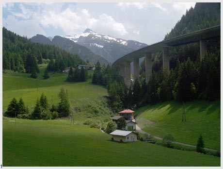
|
|
advertisement |
|
|
advertisement |