| |
| |
US191 Mogollan Mesa s(u) aka Blue Vista s(u) US191 between Alpine and Clifton
is a unique American road. It crosses the
Mogollan Rim. Yes, I know, It's not the only
one. But - there are extensive stretches with
more degrees of curvature, when added together
would make a virtually never ending corkscrew.
There are a few straight stretches along the
way, but they are few and far in between. The
Blue Vista viewpoint is the most extensive
view along this road, and the highest point on
US191 is not far from there. So far -
definitely my favorite paved road point on the
rim.
Approaches The Mogollan Rim is a well know
landmark. Not surprisingly it is located on the
edge of the Mogollan Mesa. It is slanted, much
like a hogback ridge, and the road on this side
goes up the dip slope, that is along the slanted
surface, very roughly speaking. But it explains
why this is a long, uniform-as-can-be climb
through gentle mesa slopes, for the most part.
The real curvy sections come on the other side.
There is commerce at Hannagan's Meadow, as well
as a meadow, and then a gentle road leads by
tempting trail and lookout turnoffs to a
windblown high meadow above the trees. The view
to the north is far reaching and impressive if
one can pick out some of these super distant
landmarks. There are no formal indications that
this is the highest point between Springerville
and Clifton. 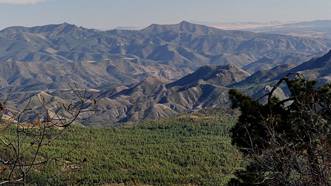 From South.
(described downwards). While continuing on
through the woods, there comes a point when you
realize you are definitely on the edge of
something. There have been a few hints before:
distant ranges through the trees, somehow
located below the horizon. But at the Blue Vista
viewpoint the rim becomes an undeniably
spectacular view in 270 degrees. This scenic
high point is about 300ft lower than the
elevation high point. The name comes from the
Blue Mountains to the east, even if to me they
look all green. The first steep step in this
decent can be seen ahead, a straight line along
the verdant slopes. From here on the road also
changes drastically in character, no more
straight aways, but super tight curves, which
you would perhaps not expect in the roadrunner
coyote state. This first step goes down a little
over 2000ft. Here the scenery seams to level
out, but the road is really toying with the top
of another ridge behind the trees. This soon
becomes apparent from the far views left and
right. After a relaxing flat section in the
woods, the next smaller climb goes up Telephone
Mesa .
 Dayride
with this point as highest summit Dayride
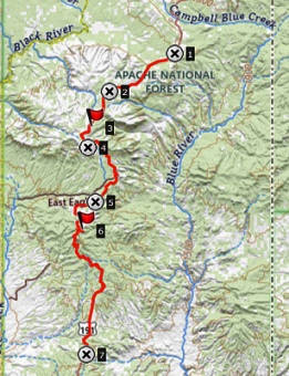
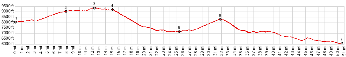
with this point as highest summitCOMPLETELY PAVED: ( < Az273 White Mtn Rd s(u) | Az78 Three Way - Mule Creek s(u) > ) US191 Mogollan Rim s(u) x2 , US191 Telephone Mesa s(u) x2: US191 at ~7170ft near fire overlook or jct with Ad Bar Trail <> US191 north <> US191 Telephone Mesa <> US191 Mogollan Rim s(u) << turnaround point at jct with FR26 at ~8050ft : 79.8miles with 7550ft of climbing in 7:41hrs (garmin etrex32x r4:24.11.2) Notes: contains 1 or 2 miles of extra exploratory detours |
|
|
advertisement |
|
|
advertisement |