| |
| |
Az78 Three Way - Mule Creek s(u) The mountains around the mining
town Clifton are full of surprises. Not only
is there a 5000 foot climb on paved roads to
the north, up to the Mogollan Rim. The way
over to the Gila Mountains in New Mexico is
also a great bicycle rouyte. I find especially
the lower 2500ft interesting, where the views
to the mountains are far and unobstructed.
After that, going over the top is pure forest
relaxation.
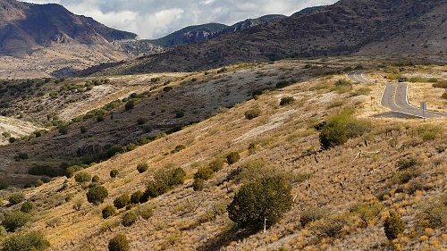
Yes - this looks promising. Wide
large radius bows climb up the range. Progress
can be measured in relation to several memorable
rocky islands of sorts. Near the top of the
plateau a rocky gate signals the entrance into a
more peaceful forested section. Without studying
a map, you never know around here how this will
turn out. This could be just the beginning of a
multi step climb. But actually the top is close
at hand, hidden in obscure dark forest, without
a sign or a hint that it is the top, only about
300ft higher, after saying goodbye to the great
views.
From North.
(described downwards). A gentle decent leads
to a pleasantly forested low point, before
another small climb propels the rider into New
Mexican territory. This second climb is around
300ft. But there is no way to make it a 500ft
climb. So I will not count this as a separate
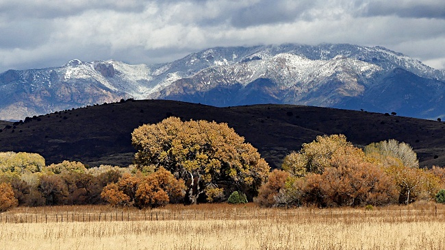
summit. Crossing over the top a distant view of
the Gila Mountains look especially impressive
when it just snowed the first time in the fall.
On this 4th of November it seems I have the
smooth pavement, the snowy mountains and the
stately colorful trees all to myself. A fast
decent leads to a closed post office that is
honored with a name on the map: Mule Creek.
Dayride with this point as
highest summit
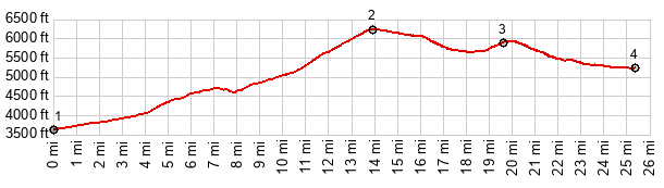
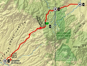
COMPLETELY PAVED: ( < US191 Mogollan Rim | HL Saddle > ) Az78 Three Way - Mule Creek s(u) x2: Black Hills Backcountry Byway not far from jct with US191 <> US191 south <> Three Way <> Az78 north <> Az78 Three Way - Mule Creek s(u) << turnaround point at Mule Creek Post Office: 64.0miles with 5460ft of climbing in 6:10hrs (garmin etrex32x r4:24.11.04) Notes: definitively more than noticable wind on the way back |
|
|
advertisement |
|
|
advertisement |