| |
| |
Az273 White Mountain Rd s(u) The White Mountains are strange
mountains, and this is the highest point on
the White Mountain Scenic Road. These
mountains are really flat, at least that is
the impression you get when getting to know
them on this part of Az273, A mesa would be a
better descriptive term. This is a summit over
a extensive rolling, high, lava capped mesa.
But to get here a very nice climb was
involved. This seems to be a relatively new
paved road. The surface not only seems but
really is in perfect condition as of 2024, and
in October at least there is less traffic up
here than in paradise before god spoiled it
with people.
From
North-2. (described downwards) Soon lakes
appear out of nowhere, Crescent Lake, then
prosaically named Big Lake. Excellent pavement
continues down to South Fork and Alpine. The
junction with the Az261 part of the White
Mountain Road is between the two lakes. Its
summit is about 100ft lower than this one, but
all the rolling along that the road does is a
bigger factor in the workout.
Dayride with this point as
highest sumit:
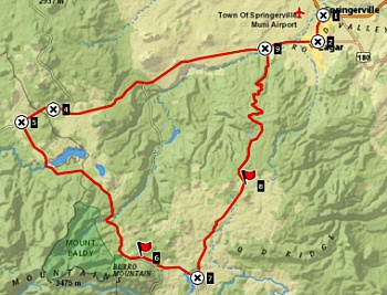
COMPLETELY PAVED: ( < Az261 White Mountain Rd s(u) | US191 Mogollan Rim s(u) > ) Az273 White Mountain Rd s(u) , Az261 White Mountain Rd s(u) :additional out and back: near Az261, several miles from its junction with Az260 > down Az261 > Az260 west > Az260 Eagan - Indian Pine(shp) > Az273 south > jct with Az261 <> out and back on Az261 direction South Fork << turnaround point at ~8700ft >> Az261 north ? Az261 White Mtn Rd s(u) > back to starting point near Az261, several miles from its jct with Az260 : 64.4miles with 4400ft of climbing in 5:53hrs (garmin etrex32x r4:24.10.31) Notes: contains a small distance of unpaved road to approach the loop 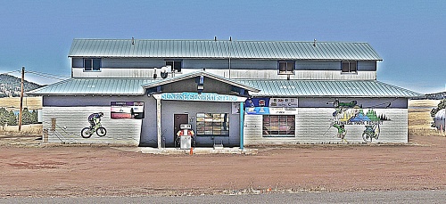 single pump ski lodge with mountain bike decor |

 Meanwhile the road has
crossed into the Apache Reservation. Every litte
bump on this pleasant rollling trip on a wide
traffic-free road is suspect of being the
summit. After all - there is a ski lodge here,
albeit with only a single gas pump and a
pleasant low key feel to it. There is nothing on
the horizon to make you suspect that this is the
top of a mountain range, at least it's called a
mountain range, the White Mountains. But this is
actually the fact that makes this ride so
fantastic, the knowledge that it takes a climb
to get to this lava plain. In the end there is a
noticable climb, as the road crests a what could
be considered a giant rumpled tortilla on a
paper plate supported only in the middle, and
the view shed takes in the grassland to the
south.
Meanwhile the road has
crossed into the Apache Reservation. Every litte
bump on this pleasant rollling trip on a wide
traffic-free road is suspect of being the
summit. After all - there is a ski lodge here,
albeit with only a single gas pump and a
pleasant low key feel to it. There is nothing on
the horizon to make you suspect that this is the
top of a mountain range, at least it's called a
mountain range, the White Mountains. But this is
actually the fact that makes this ride so
fantastic, the knowledge that it takes a climb
to get to this lava plain. In the end there is a
noticable climb, as the road crests a what could
be considered a giant rumpled tortilla on a
paper plate supported only in the middle, and
the view shed takes in the grassland to the
south. |
|
advertisement |
|
|
advertisement |