| |
| |
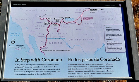
Montezuma Pass In spite of the historical
allusions in the name, Montezuma Pass through
the Coronado National Historical Park is not a
historical pass. It is however a incredible
vantage point, from where to visualize a
historical spectacle - not a battle this time,
but an actual journey with consequences:
Coronado's entrance into what is now the US,
even if at the time it was all "just"
ancestral Mexico in all directions. As far as
I know, there are no reports of actual people,
who have seen this spectacle from this point.
But at least some animals must have seen it.
In any case, like a great film director, it
does not deter from the power of visualizing
this spectacle from this vantage point.
 Approaches
But the best part is the short
.4mile walk from the pass to Montezuma Peak, a
rounded hill that gives the view that the
historical park promises. Along the way are not
only cacti and interesting plants to serve as
foreground for the endless procession of hills
in 270 degrees, but now also various tablets
that help you visualize Coronado's entrance into
the valley below with more historically correct
detail. How many were there ? What did they
bring along ? Where did they go ? It is now a
bit more of an educational experienced, where
you feel like somebody is taking you by the hand
and telling what to think of. During my first
ride up here 22 years earlier it was a more
intimate experience of privilege, that came from
having found a rickety old bench on top of a
rounded hill in a extraordinarily unique
location. But both approaches have their
advantages, and the more people there are, the
more you have to take the educational approach. 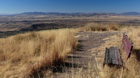
From West. (described
downwards) Gone are the switchbacks of the
eastern side. On this side the road takes a
relatively lazy traverse along the Huachaca
Mountains. The rounded hills on the Mexican side
of the Sonora Dessert are like different types
of waves in an ocean of grass. Soon the road
curves from one bridge over an arroyo to the
next, linked together by more gentle bends
through a scrubby forest. Progress on this road
may be slower than planned. It is pretty rough
and somewhat washboarded too. In order to maximize the approach
height on this side the route turns south
towards the border onto R62 Lochiel Road and
ends at the county line. For a very long dayloop
you would continue straight at point 4, without
loosing substantially more elevation. Slideshow of the road approaches
to the pass
Dayride with this point as
highest summit:
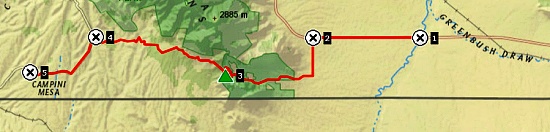
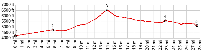
PARTIALLY PAVED / UNPAVED ( < Middlemarch Pass | Mule Pass > ) Montezuma Pass x2: near jct Az92 - Hunter Canyon Rd <> Az92 south <> Montezuma Canyon Rd south west <> Montezuma Pass <> FR61 Lochiel Rd south west << turnaround point at county line ~5490ft: 50.5miles with 4850ft of climbing in 5:54hrs (garmin etrex32x m6:24.11.18) Notes: finished ride with a flat in the last mile |
 But
things get more interesting after the turnoff
onto Montezuma Canyon Road. The first miles are
smooth refined pavement, past affluent
retirement homes, that seem to congregate around
every national park, monument, or in this case
historical park.To the north the attraction is
the Huachuca Mountains and the sweeping grass
fans that lead up to them. To the south it's the
border fence, and behind that rounded grassy
hills in another world. The pavement lasts past
the historical park visitor center and it stops
before the first switchbacks begin. After a
respectable gravel climb, there is quite a nice
view of all the curves below and the mountains.
Montezuma Pass now has a sign with elevation, as
well as roofed picnic tables, toilets and more.
But
things get more interesting after the turnoff
onto Montezuma Canyon Road. The first miles are
smooth refined pavement, past affluent
retirement homes, that seem to congregate around
every national park, monument, or in this case
historical park.To the north the attraction is
the Huachuca Mountains and the sweeping grass
fans that lead up to them. To the south it's the
border fence, and behind that rounded grassy
hills in another world. The pavement lasts past
the historical park visitor center and it stops
before the first switchbacks begin. After a
respectable gravel climb, there is quite a nice
view of all the curves below and the mountains.
Montezuma Pass now has a sign with elevation, as
well as roofed picnic tables, toilets and more.
|
|
advertisement |
|
|
advertisement |