| |
| |
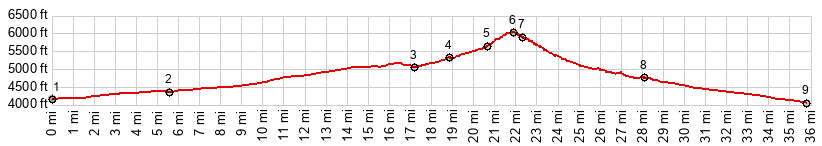
Mule Pass Everybody I talked to in Bisbee
made me think this was a really difficult,
steep climb, far above a modern tunnel through
the base of a large mountain. But this is no
Sankt Gotthard Basis Tunnel. But I can
understand the difficulty of bicycling this
pass in the usual hundred degree temperatures.
I would probably have to walk the entire
thing. Luckily I was here on a cool November
day, and the climb over the summit was barely
a workout. Another thing that makes this pass
special are the very long and straight, barely
noticeable lower alluvial fan approaches, that
make up a good percentage of the total
climbing.
Bisbee comes in parts. First there
are a few businesses in "modern buildings" along
Az92, including a supermarket, then after the
turnoff onto Az80, a block of what looks like a
stage set, complete with especially arranged old
cars from the 50s and other car wrecks. It goes
very well with the adjacent remnant of an open
pit mine. But if you don't take the little
detours, it's just good old four lane highway
climbing. The actual old town Bisbee is another
one of these detours. It has all sorts of
interesting buildings and businesses catering to
tourists. The choice is to ride through it or to
view it from slightly above on Az92, not a bad
choice either. When old Bisbee ends and the
moment of rejoining Az92 draws near, an unsigned
turnoff goes under Az92 for the short and sweet
climb to this pass. It's really just a couple of
turns that lead above the modern road and its
short tunnel (which I almost want to call a
bridge). Nontheless there is a fine view
downvalley. On the top the viewshed changes to
include a radio tower above.
From North.
(described downwards) The decent before the
Old Divide Road rejoins Az92 is barely worth
mentioning. On this side it is a fast, smooth
decent on the shoulder of straight, fast
highway. As the profile turns onto Az90, only
the distant ranges behind Sierra Vista and
Tombstone limit the vista to the extreme
horizon. The road continues to descend almost
imperceptibly on the ever-so-slightly slanted
alluvial fan. Again the noticeable low point,
which is also the environmental high point, is
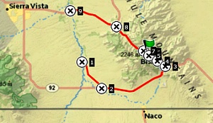
the crossing of the San Pedro River. 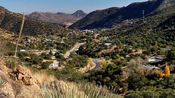 Dayride with this point as highest summit: COMPLETELY PAVED ( < Montezuma Pass | FR184 Amado - Mt Hopins Rd s(u) > ) Mule Pass , Az92 Sierra Vista - Montezuma Historical Park s(u) , additional out and back : jct Az92 - Hunter Canyon Rd <> out and back on Three Canyons Blvd << turnaround due to gated road <> separate out and back on Andalusian Blvd << turnaround due to end of road >> Az92 east with out and back detour due to end of road >> Palominas Rd north > Hereford Rd east > Az92 east > Bisbee > Old Divide Rd north > Mule Pass > Az90 west > Moson Rd south > Hereford Rd west > Az92 south > Az92 Sierra VIsta - Montezuma Historical Park s(u) > back to starting point at jct Az92 - Hunter Canyon Rd: 75.5miles with 3860ft of climbing in 6:25hrs (garmin etrex32x r4:24.11.20) |
|
|
advertisement |
|
|
advertisement |