| |
| |
Heliograph Peak (Mt Graham) The paved road up Mt Graham is
one of three, really well known, paved, out and
back cycling climbs in Arizona. But since it's
far from any city or other cycling
infrastructure, it seems to not have any cycling
traffic, unless perhaps, some huge, organized
mass group ride from Tucson or Phoenix descends
onto Safford. Much of the pavement is also very
cracked (Nov 24). Despite of its huge elevation
gain, the top of the mountain is still about
2000ft lower than the highest peak in Arizona.
The highest peaks are far to the north in this
grand Arizona staircase.
There are two obvious radio
facilities on the top of the ridge, that is Mt
Graham. Both are accessible by unpaved roads.
Heliograph Peak is a couple of hundred feet
lower than the other one, but also much easier
to get to, especially when snow and mud make
the journey more difficult to the higher peak.
The ride to Heliograph Peak is also quite a
bit shorter.
The turnoff onto Az266 features a
road as straight as a ray heading for the ridge
straight on. That will be the last straight line
road view for the rest of the day. The first
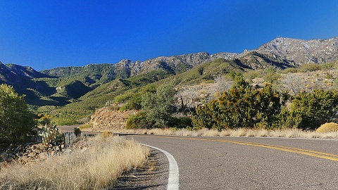
part of the climb is in open dessert scenery.
The ridge above slowly draws closer. Once this
section draws to a close, there are are some
fine views of spaghetti roads below. They are
wide spacious turns, as if the spaghetti have
not been fully cooked, not tangled one on top of
the other.
Heliograph Peak Road actually turns off Az266 before the pavement ends. Best to go to the end and then turn around and take not the first, but the next unpaved road heading east, in the direction of the microwave tower visible above. All the other unpaved roads I have tried up here were near to impassible because of snow and mud. But this one to Heliograph Peak was just fine. Go figure. A few small switchbacks quickly lead to a section with fine views - but nothing that compares with the stunning panorama that waits at the top. The Lookout Tower is not barricaded and can theoretically be climbed, even though signs forbid it.
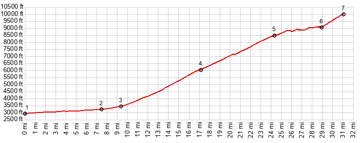
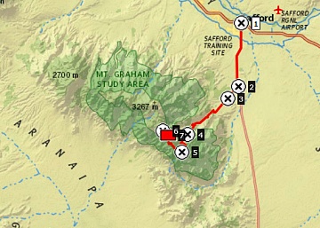
Dayride with without two-way
summits and this one-way summit as highest
point
( < Stockton Pass | Onion Saddle > ) near Az366 Cyclone Hill area at ~3850ft > up Az366 > end of pavement at 9200ft <> out and back continuing on Az366 down to low point at 8800ft where road crosses Grant Creek <> short separate out and back from end of pavement on FR502 Graham Creek Rd <> separate out and back on Helipgraph Peak Rd to Lookout tower << down Az366 <> past starting point with turnaround point on Az366 at jct with W Boulder Lane at 3550ft >> back to starting point in Cyclone Hill area:52.1miles with 7780ft of climbing in 7:25hrs (garmin etrex32x r4:24.11.11) Notes: just to emphasize. My ride did not start in Stafford like the profile does, but ~1800ft higher. The plan was to ride Az366 to tne end. But when the pavement surprisingly stopped, the road on the west side in heavy forest turned to snow and mud, prompting me to look for alternate plans. This Lookout Tower actually was better than anything I could have planned. 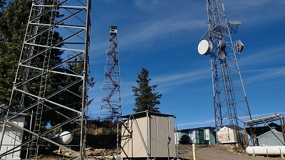 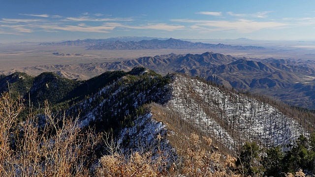 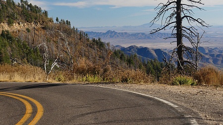 |
 The next section of
the climb takes place in deep forest. This is
the area where vacation homes hide in the woods,
and the temperature drops drastically. On my
ride the first remnants of snow start to appear
next to the road. Another series of switchbacks
and the now improved pavement, the road switches
to the west side of the ridge. Even the tops of
the Pinaleno Mountains are now far below. The
only road visible below are the bows of pavement
to the top of
The next section of
the climb takes place in deep forest. This is
the area where vacation homes hide in the woods,
and the temperature drops drastically. On my
ride the first remnants of snow start to appear
next to the road. Another series of switchbacks
and the now improved pavement, the road switches
to the west side of the ridge. Even the tops of
the Pinaleno Mountains are now far below. The
only road visible below are the bows of pavement
to the top of |
|
advertisement |
|
|
advertisement |