| |
| |
This is one of those roads, when
you look on it on a map, you may ask yourself:
"I wonder if this is paved". This may be one
reason why it is such a great low traffic
dessert bike ride, and yes - it is paved. This
ride over the southern shoulder of the
Pinaleno Mountains has great rock scenery too.
Az266 is a whole other bike ride
(or ball game would be the going phrase). As far
as I can tell the main reason for its excellent
paved condition just may be the Arizona State
Prison on the other side of the pass. The climb
into this dessert range crosses a geologic
formation (in the sense of rock layer) that
erodes into small exfoliated sphere, much like
the Dakota Sandstone in Colorado. There are few
turns in this road, but the traffic is virtually
non existent and the scenery sublime dessert
rocks. The top is definitely a noticeable climb.
There is no pass sign, unless you count the one
that says "Stockton Pass campground". The name
is also present on many maps. 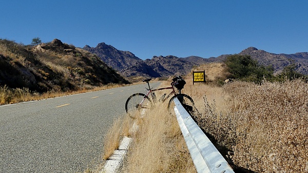 From West. (described
downwards). The elevation difference is quite a
bit smaller on this side. The state prison comes
into view first. Miles away, you notice
something that looks like a fairly large town,
maybe centered around a spa or a hot spring ? It
is a pictureque location, plastered against the
green face of the Pinaleno mountains. The site
also includes an industrial school. Closer to
the route of direct travel, the stately
cottonwood (?) groves of Bonita come into view
next. There is a large functioning elementary
school there, surrounded by what looks like
remnants of a previous town. Fenced in buildings
are in a state of decay. But the fading letters
"store" still hint at commerce that has long
since died. Mostly the place seems to be used to
store hay. Pavement turns south here direction
Winchester Heights. This is duly noted for the
future possibility of a day loop ride.
Dayride with this point as
hghest summit:
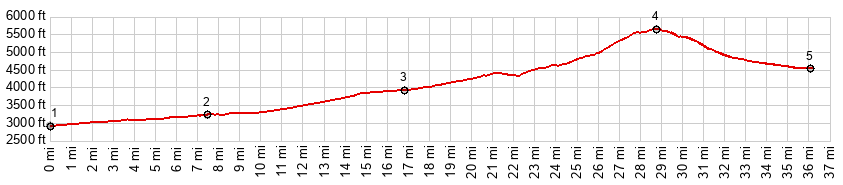
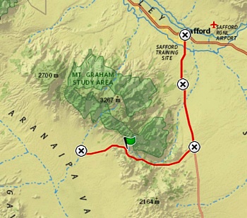
COMPLETELY PAVED: ( < HL Saddle | Heliograph Peak(ow) > ) Stockton Pass x2: near jct near Coronado NF boundary on Az366 <> down Az366 with short detour <> US191 south <> Az266 west <> Stockton Pass << turnaround point Bonita Elementary School: 68.8miles with 4850ft of climbing in 6:15hrs (garmin etrex32x r4:24.11.08). Notes: too cold for Mt Graham, but perfect for this summit. This could also be advertised as a prison to prison ride: from the Mt Graham Swift Trail federal prison ot the Arizona Fort Grant State Prison (and back). |
|
|
advertisement |
|
|
advertisement |