| |
| |
HL Sadddle The most interesting climbs
often have several different parts, that
contrast each other. Even if one of the parts
is maybe not so enjoyable, it adds to the
whole experience, just because it is so
different from the rest. This pass (or saddle)
is certainly like that. One part travels
through the largest open pit mine, that I have
ever seen in my life, and could not even have
imagined without having seen it. The other
travels through what appears like a complete
mountain wilderness with road, that seems to
be perfectly made for cycling.
The first part is definitely
different, I would say unique. A busy climb on a
very crudely paved road climbs to the first
industrial mining fixture on the first mesa. The
town Morenci carries the name of the mining
company whose operation we will be traveling
through for the next hour or two. Here too,
street photography will have to wait for a later
date. Soon the road enters a large pit mine. It
goes right through it. Copper ore crosses over
the road on a conveyor belt and is dumped from a
100ft onto in a noisy rock fall. Monster trucks
scurry over and under US191 on special
constructed roadways. The scenery resembles one
large stair case. From each shelf successive
layers of the mountain are removed. This is the
largest copper producing area in the US, and the
only open pit mine that I have seen, that has a
large public roadway right through it. The air
is constantly filled with haze and has a
peculiar smell. But even through the width of
the road does not decrease, traffic certainly
does. So even though it feels and looks like
Armageddon, it is an Armageddon almost without
cars ... until we have climbed 2000ft higher
than where we started and are still surrounded
by industrial staircase scenery. There was even
a "scenic overlook" back a mile, complete with
directions of how to apply for a mine job in two
languages. 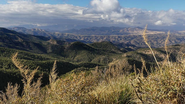
Where the mining rubble ends, a
300ft decent goes back down to Chase Creek, same
creek we started on, but still without signs of
the things that await it downstream. It is a
miracle the creek survives till the bottom, in
some form or other. Suddenly - the road, the scenery,
the feel could not be any more different. A
curvy road slowly bids farewell to the creek and
climbs in snake like ramps up the side of the
canyon. Across a chasm more corkscrew turns on
the other side project ever higher. The haze
over the mine slowly fades into the distance.
All those curvy road lines look even better from
the higher you get. Eventually the mountain
ranges, limiting the view east and west take on
the new center of attention, as I gasp for
breath, climbing this variably bouncing and
bounding slope. The Gila Range over in New
Mexico seems to retain the first snow fall of
the year the longest, while Mount Graham to the
west slowly fades into flatness with the sun
appearing over it. HL Saddle comes sort of as a
surprise. You can't really see it clearly form
this side. The attractive spot has a sign, a
trailhead, a picnic table and a short path that
allows for a variety of imaginative cactus
figures in the foreground of mountain pass
photos. The highest point is just slightly north
of the sign. Slideshow of section Chase Creek
- low point north of HL Saddle
From North.
(described downwards) What follows is a
traverse with clear views onto the shapely
distant hills for a mile or two. A flury of
curves descends over what almost could be a
perfectly located medieval village in another
continent, but turns out to be an outpost of the
Arizona Highway department. Soon the road
straightens and has the high grazing territory
of Turkey Creek in its sights. The apparent
human emptiness surrounding this curvy thread of
travel is spellbinding. Slideshow of section: Clifton -
Morenci - Chase Creek
Dayride with this point as
highest summit
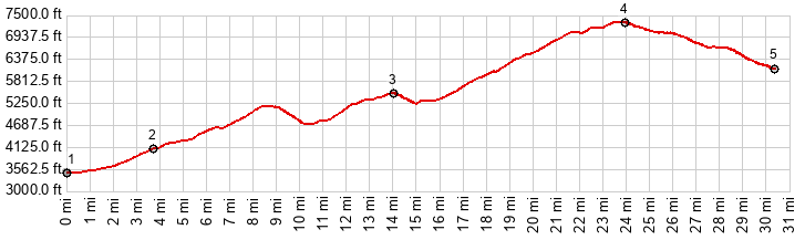
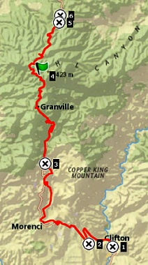
COMPLETELY PAVED ( < Az78 Three Way - Mule Creek | Stockton Pass > ) HL Saddle x2 : near jct Black Hills backway - US191 <> US191 north <> Clifton <> Morenci <> HL Saddle < turnaround point a jct with Juan Miller Rd : 70.4miles with 7600ft of climbing in 7:18hrs (garmin etrex 32x r4:24.11.05) Notes: perfect day with sunny sky and suitably cool temperature, little to no wind 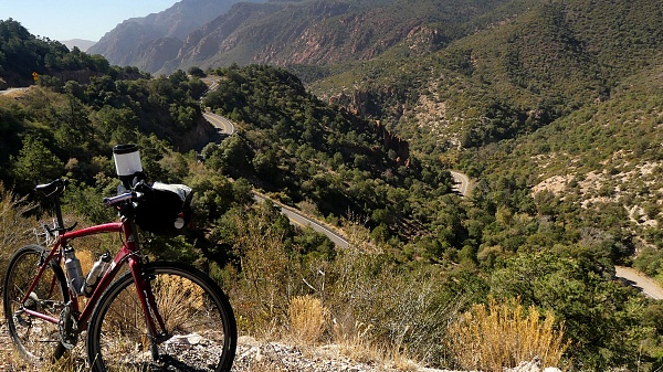 |
|
|
advertisement |
|
|
advertisement |