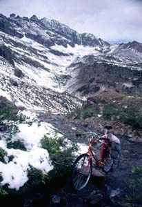
Pearl Pass

The Pearl Pass road is the highest jeep trail crossing the Elk Range. The top is always rocky, often snowy, and more than anything, spectacular. The most stunning sight along the way, may well be the wall of Castle and Conundrum Peaks along the upper southern approach (see pictures). During a cloudy September day, it can be as intimidating as the decent into the colorful, whispering leaf canopy over Crested Butte can be soothing.


click on profile for more detail
01. (mile00, 7923 ft) START/FINISH NORTH: outskirts of Aspen, turn up Castle Valley South of town
02. (mile14, 9743 ft) START/FINISH NORTH ALTERNATE: Pearl Pass dirt road begins at the end of Castle Valley
03. (mile17, 11118 ft) Junction with Montezuma Mine Road. Keep left on steep jeep trail
04. (mile20, 12692 ft) TOP: Pearl Pass
05. (mile29, 9177 ft) START/FINISH SOUTH: stay left at T
06. (mile30, 8954 ft) stay left at T
07. (mile32, 8916 ft) stay left at T
08. (mile35, 8915 ft) stay left at T
09. (mile35, 8853 ft) turn right onto Rte 135 into Crested Butte
10. (mile37, 8909 ft) START/FINISH SOUTH ALTERNATE: Crested Butte

Approaches

From North. The unpaved Pearl Pass Road starts at the end of Castle Valley near Aspen. However, from a profile point of view, you can argue, that it really starts in Aspen, in order to experience the full effect. The roaring fork valley below Aspen offers yet another way to increase the total elevation gain on the southern approach, but this portion has a very gentle grade, compared with the rest of the climb.

From South. Looking at the elevation profile, it looks like the ascent up the northern approach starts about 7 miles after it leaves Crested Butte. However, Crested Butte makes a more logical starting point, as well as a great overnight spot when incorporating this pass into a multi day tour.

Tours

Single Day. A single day ride out of Aspen or Crested Butte is unlikely to reach all the way down  the other side of the pass and back. Under almost all realistic conditions it is too long.

Three Day Tour consisting of jeep trails, dirt road and pavement. This pass is part of a three day circle of pass exploration in the Elk, West Elk and Sawatch Ranges. The route is as follows: day 1: Aspen, Pearl Pass, Crested Butte (40 miles, onboard measured ) (m1:86/9/13); day 2: Ohio Pass, Gunnison, Pitkin (75 miles); day 3: Cumberland Pass, Taylor Pass, Aspen (70 miles). Ohio Pass can be bypassed for an easier second day. Narrative

Three Day Tour consisting of jeep trails, dirt roads and pavement. Another possibility is to make Carbondale the starting point, or an overnight stop. One easy day would be spent riding the well constructed bike path to Aspen. The next day consists of crossing Pearl Pass to Crested Butte, and the last day leads over Schofield Pass, and a bit more pavement back to Carbondale.

Three day Tour consisting of dirt and pavement. This tour shares the first day two days with the previous route. Day one covers Carbondale to Aspen. Day two is from Aspen to Crested Butte. The return on day three is longer but much smoother, leading from Crested Butte over Kebler pass and the paved McClure Pass.

History

The Leadville Boom (<Taylor Pass|Yellowjacket Pass>): Looking at Colorado with today's traffic pattern in mind, it's an amazing fact that the Pearl Pass road was ever constructed. Why would anybody travel to Aspen over Pearl Pass ? Approaching Aspen through the Roaring Fork Valley would be so much easier on the spokes, weather they belong to a bicycle or an ore wagon.

As always, the answer is money, business and money. In the 1880s, Aspen and Crested Butte were thriving mining towns. Crested Butte was already connected to the growing railroad web, courtesy of the Denver Rio Grande railroad. Aspen however was not. This presented problems for the miners who had to transport their sliver ore out to smelters on wagons. At the time, there were three options. Independence Pass through the Sawatch Range actually predates the Pearl Pass road by a short time. Another possibility was Taylor Pass, the longest of the three routes to a railhead.

Enter the incredible Pearl Pass wagon road. Just 30 miles on the other side of the Elks was the closest railhead in existence. But those 30 miles were 30 difficult miles, as any cyclist who has ridden over this pass can testify. Miners would haul up their ore some 4600 feet from Aspen. Sometimes they had to unload the wagons near the top and winch them across, and then do the whole thing in reverse down the other side to Crested Butte. It's not surprising that this ordeal was not a permanent solution. Independence Pass drew more and more ore traffic from Pearl Pass. Eight years later, two railroad lines had reached Aspen itself, making the Pearl Pass wagon road obsolete, as far as the practicalities of the mining business were concerned. Today you'll encounter a jeep or two, and other cyclists, at least on popular weekends. This is one of the few double track jeep roads that has been embraced by single track seeking mountain bikers, even though there are many others.


Copyright (C) 2003-2008 by Michael Fiebach - All Rights Reserved