| |
| |
Juniper Pass
(including the Mount Evans Summit Road) There comes a time every spring,
when Denver area cycling clubs - one by one -
think the time is ripe for a ride over Juniper
Pass. One recent write up of such a ride in the
DBTC schedule went something like this: For
breakfast we will have Lookout Mountain
(a shoulder approach to the slightly more direct
Mount Vernon Canyon shown in the profile), for
lunch Squaw Pass,
then for dinner Juniper Pass and for desert Floyd Hill.
That just about sums up such a loop ride, the only
thing to clarify is, that the I70-Chief Hosa
exit shoulder summit is really the highest
point and not Lookout Mtn.
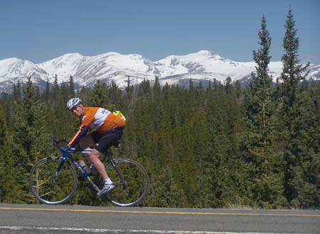
Sometimes the time that such a ride appears in the schedule is May. Often a cold wind blows but the views are crystal clear and Mount Evans as well as the Continental Divide still seems covered in a long lasting blanket of snow. Sometimes the time is June. Then it can be hot already and the sun burns down relentlessly on the lower climb. But the altitude soon offers relief. And then sometimes the time is July, when often the monsoon has started, and the riders are caught by relentless downpours during the descent. And then, on other days during the same months, the weather is just perfect. You just have to pick your days. Juniper Pass is the highest paved "home pass" with two separate climbing approaches that connect directly to Denver. Wherever you live in the Denver area, it is at least theoretically possible to leave from your house in the morning - and cross the pass, arriving back at your place by the evening, using for transport nothing but a bicycle. Such a day long journey traverses
along Chief and Squaw Mountains, far above the
valley carved by Clear Creek, and on eye level
with the mountains of the Continental Divide. It
some ways it doesn't feel like a pass. It doesn't
cross from one view shed into another, or at least
you never get any far downvalley views when you
are in the northern viewshed. The road that
doesn't feel like a pass, really crosses one pass
and just touches another. Just to add another
paradox, neither pass is at the highest altitude
of the road. That comes later.
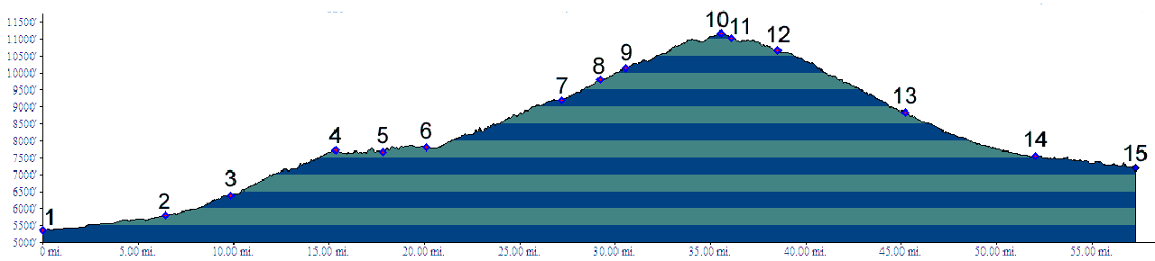
Approaches
 From South East. Biking
clubs often start their rides up Juniper Pass from
Bergen Park. This is already 2440 above the lowest
point on the profile : a convenient place on the
Clear Creek bike path, still about another 200ft
above downtown Denver at the confluence of Cherry
Creek and the Platte River.
Climbing continues uninterrupted.
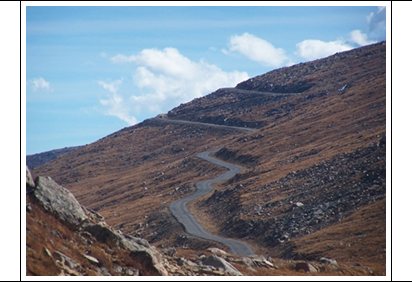
The road becomes more scenic and the contouring
traverse starts in earnest. I seem to remember
less of the climbing aspect of the road from this
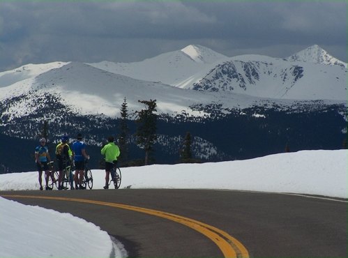
point onwards, and instead tend to remember the
views, the clouds and the light. Let the pictures
do the talking. Juniper Pass itself is located at
the Picnic area with the same name. The highest
altitude of the road is reached about half a mile
east of there.
The turnoff to West Chicago Creek
signals the beginning of a series of switchbacks.
Glimpses of the Mount Evans Massif can be caught
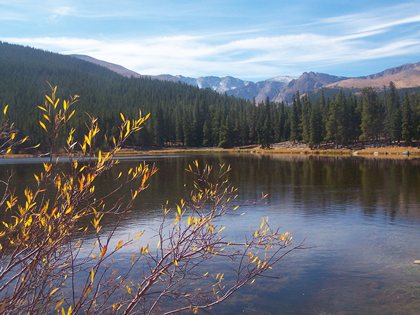
between the trees. Echo Lake marks the turnoff to
the Mount Evans summit road. Alternatively you can
eat lunch there too. It is still 500 feet below
the highest point of the Juniper Pass road. Many
riders from Bergen Park also us this as a turn
around point, for an out and back ride. 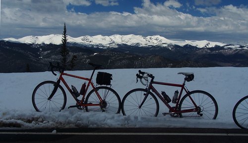
Sidetrip to Mount Evans: Calling a ride to the top of Mount
Evans a sidetrip from Juniper Pass is obviously an
understatement. But I decided to group all one-way
climbs with the nearest pass, and that is Juniper
Pass. After two switchbacks connected with
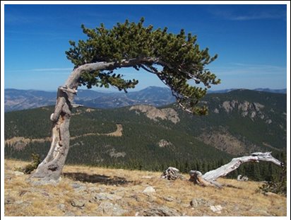
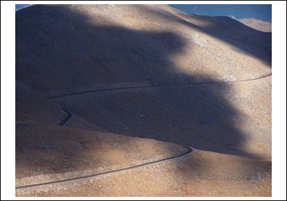
long straight ramps the road climbs out of the
forest at a large grove of Bristlecone Pine trees.
A visitor center has been erected at this popular
stopping place. The forest ends and the rock scape
begins. The road ahead can be seen as a straight
line slicing up the loaf shaped mountains. You
suspect a saddle where the road cut ends. But this
is just the point where the next view shed
appears, and it the next view shed after that is
also very similar. But now there is an added
attraction, the oval shaped Lincoln Lake below.
The road embankment forms a sheer cliff without a
guard rail at the point The road was washed out
here during the winter of 2015. Now the road is
repaired with a flawlessly, smooth new surface.
But so far there is nothing separating the road
from the depths below. This is one place where
descending on the left side of the road seems
common sensical. This next slice up the breadloaf is
the last one. The road descends about 200ft to
Summit Lake. The frost cracks approaching the lake
are the worst here on the entire road. They cracks
are curved like miniature canyons and their edges
are rounded like a fluid substance. Here a short
unpaved path leads to an overlook over the Chicago
Lakes below. Foot trails lead up Mount Evans and
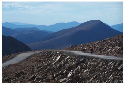
down to Chicago Lakes. The last part of the climb starts
and surprisingly the road surface gets better
again with more elevation. After two switchbacks
the viewshed changes to the south, and by the time
a cyclist makes it to this point the light has
invariably changed to a flat frontal light, so
that it's hard to make out distinct far features
on this side This point is identfied as Campion
Pass in Helmuth's book "Passes of Colorado". The
road crosses this saddle between Mount Evans and
Mount Epaulet above the lowest point of the
saddle. There is absolutely no downhill involved
as far as the road is concerned. It is named for a
surveyor who died here of exposure during
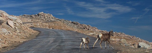
construction of the road. Nine more switchbacks and a couple
of curves lead to the top. During my last ride up
here, in October when the road was already closed
to motor vehicles, I encountered many mountain
sheep here, on the way up as well as down. The two
middle switchbacks on the west side afford great
views onto Grey's and Torrey's Peaks behind the
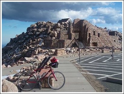
cliffs of the Evans Massif. The top comes up surprisingly and
seems like it's not reaching the top of the
mountain itself. Acutally it isn't. This 100ft
pile of rocks, which is the real summit has no
established track to the top and actually blocks
the view to the north west. I imagine that was the
plan because it also blocks the wind. Instead
there are "pay-ruins" from a formerly magnificent
summit house, located on a lower knoll of rocks to
the east (more details in the historical notes
below) It is safe to assume that the "hang
from the handlebars" type bike rack for 10 bikes
in this parking lot is the highest bike rack in
North America. The best time for this ride is the
very short period, starting after the fall closure
of the road (for motor vehicles) and the first
snow. All the pictures on the right and in the
slide show were taken during that time. Historical Notes Modern Roads: The road from
Denver to the summit of Mount Evans was achieved
in steps, and most steps were preceded by a
political battle. To get the ball rolling the
Denver Parks system decided to build a series of
scenic automobile loops for Denver residents. One
of these was Loop G, and the first leg from Genesee
Saddle (today's I70 Genesee exit) reached
closeby Bergen Park in 1915. Subsequent political
battles about a road that "starts nowhere, goes
nowhere and never gets there" ( a quote from the
Commissioner of Improvments WFR Mills) delayed the
start of road construction to Squaw Pass to the
spring of 1918. The plan was to make Mount Evans a
national park in order to get federal aid for road
construction. This was a time of bitter animosity
between the National Forest Sevice and the yet to
be formed National Park Service, and the Mount
Evans National Park never came into existence. In
any case, it would have been the "Monte Rosa"
National Park, named by the famous painter of
Romatic American landscapes, Albert Bierstadt.
Rosa was somebody else's wife whom he married
subsequently. But it was also an allusion to the
highest peak in the Swiss alps by the same name. The road from Soda Pass (today named
Squaw Pass) to Echo Lake was finally started in
1919 and took two years to cross Juniper Pass and
reach Echo Lake. Instead of the National Park
Service the newly formed "Bureau of Public Roads"
picked up part of the costs. The road to the summit from Echo Lake was surveyed again two years later, in 1923. It took another 7 years till the last switchback to the summit was completed by hand. The ruins on the top look at first
sight like something constructed by the Civil
Conservation Corps after the Big Depression. They
have that unmistakable solid look. But actually
the Crest House was constructed much later, during
1940-41 through private initiative. The story goes that a German
immigrant, Justus Roehling, wanted to impress his
girlfriend and future wife with a "castle in the
sky". Financial backing came from the owner of the
Broadmoor Hotel in Colorado Springs and a future
mayor of Denver. Roehling, his wife and workers
lived in tents on the summit during the
construction. During the winter of 1940, still in
the construction stage, much of the glass and
woodwork was destroyed. In 1941 the repairs took
place and the building opened as a restaurant,
gift shop, rest rooms, observation deck and
emergency oxygen dispenser, which sounds much more
practical than "impressing your girlfriend with a
castle in the sky". The center piece of the
building was a two story star-shaped glass and
steel platform. The outside was completed with
nearby rocks that fit perfectly into surroundings,
because they were the surroundings. The original
lease stated that the property reverts to the
National Forest Service in 1969, and so it did. After another 10 years, In 1979, the
building burned down because an employee of an
Evergreen propane company did not secure a safety
valve. The National Forest Service only succeeded
in getting less than 25 percent of the estimated 2
million dollars in replacement costs from the
propane company.
Cycling-Racing: A bike race
from Idaho Springs to the summit of Mount Evans
was first held in 1962. It was first named the
Mount Evans HIll Climb, and later renamed the Bob
Cook hill climb, who won the race five times
between 1975 and 1980 and later died of cancer. Up
to 2015 the race was only canceled twice due to
weather. The winner covered the 27.4~44.1km miles,
climbing the 6590ft~2008m (not counting the
roughly 200ft of "rolling hills along the way) in
a time ranging from 2:28hrs in 1962 to 1:48hrs in
2015. To compare this elevation gain with
just one famous pass in the alps, Passo Stelvio:
In order to loose 2000 meters from the summit you
would be 40.5km down on the north side, somewhere
between Schlanders and Laas, and 46 km down the
south side. This seems comparable to the 44.1km
from Idaho Springs. But the slope here is more
uniform over the entire distance, while you have
to reach well down into the valley approaches on Passo Stelvio
to get this elevation gain. Cycling-Touring: (<Independence Pass|Nine Mile Gap Summit>):
The Juniper/ Squaw Pass combination was once part
of the Denver Post's "Ride the Rockies". Between
86 and 05 the tour crossed the passes on the last
day of the 88 tour when returning from Idaho
Springs to Golden. The Triple Bypass ride is another
organized ride (by Team Evergreen), that people
have loved to use as an incentive to train hard
for several decades. It ends in Vail and goes over
Juniper Pass, Loveland
Pass and Vail Pass.
|
 When starting from Bergen Park
there is little time to warm up. The climbing
starts right away. Squaw Pass Road starts with a
mighty ramp up into the forested mountains. Using
dirt roads there are many higher access points
onto the Squaw Pass Road, making many shoulder
summits. These are
When starting from Bergen Park
there is little time to warm up. The climbing
starts right away. Squaw Pass Road starts with a
mighty ramp up into the forested mountains. Using
dirt roads there are many higher access points
onto the Squaw Pass Road, making many shoulder
summits. These are 
|
|
advertisement |
|
|
advertisement |