| |
| |
Colorado Trail m175.7(sh)
(Upper South Elbert Trailhead)
This is a rare section of the
Colorado Trail along the Wasatch Range, where the
route runs far enough away from it, so that you
can get a good view of it. It is also a very short
section, so that it is also included in the
section Colorado
Trail m171.6 s(u).
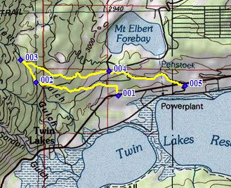
Directions involving the South
Elbert Trailhead can be confusing. That's because
there are two of them. Drive up the only paved
road north from Twin Lakes past Lakeview
Campground, and you'll find a prominent national
forest sign behind a parking lot saying "South
Elbert Trailhead", together with a Colorado Trail
emblem pointing the way. Look close to the right
of the parking lot, and you'll see a sign saying
South Elbert Trailhead 2 miles, pointing up
FR125.1B (as of summer 2011). To avoid confusion
I'll call the first one the lower South Elbert
Trailhead, and the second one the upper South
Elbert Trailhead. The upper trailhead is the point
of highest altitude between the Colorado Trail and
FR125.1B.
From South. The Colorado Trail on the
north side of Twin Lakes runs between the lake
shore parking lot and Co82. A convenient place to
pick it up for this climb is as it passes under
the road, a short distance west of the most
prominent building on this side of the lake. There
is also a Colorado Trail sign there. The trail
angles westwards and passes by a few campsites of
the Lakeview campground. During my particular Labor Day visit this area
felt just a little bit like the Denver area Cherry
Creek bike path ride in the spring. The same
people who could be watched barbequing from the
Cherry Creek bike path in spring, could now be
observed at the same activity next to the Colorado
Trail on Labor Day.
At the next intersection a extreme hard right leads to the lower South Elbert Trailhead. If one happens to be coming from there and wants to go down to the lake, you have a hard time guessing that you have to take a left turn here. But continuing up towards the upper trailhead,
the route goes by some great views of Mount Huron
and the lake, then enters the forest, converges
with another direct trail to the town of Twin
Lakes and finally climbs steeply to the upper
trailhead. Where it converges with the road, is
about 50 feet lower than the upper trailhead, just
where the cars start clogging the space between
the trees.
From North (described
downwards): The road stays a little lower than the
trail, and you now you can see the little lake you
passed from the other side. The road emerges as
FR125.1B at the lower trailhead. From there it's a
fast paved descent to Co82. Another option (not
shown in profile) is to to ride around the Mount
Elbert Forebay and descend towards US24 on rough
pavement and a short stretch of dirt.
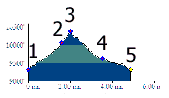
Dayride with this point as highest summit: Colorado Trail m175.7(sh) , Colorado Trail
m185.7 s(u): lower South Elbert
Trailhead area > CT to Colorado Trail
m175.7(sh) > down FR125.1B > paved
road to Twin Lakes > Colorado Trail across Twin
Lakes Dam <> out and back on unmarked FR
south of Twin Lakes to jct with FR114 >>
Colorado Trail m185.7 s(u) > Colorado Trail
m185.7 s(u) > down FR120 > north on US24
> Granite > Co82 to Twin Lakes > a few
miles looking for trail > Colorado Trail back
to lower South Elbert Trailhead area: 38.9miles
with 3910ft of climbing in 5:00hours (VDO MC1.0,
m3.11.9.3, t11_6).
|
 Approaches
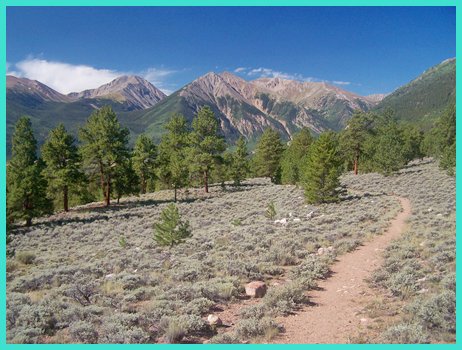
|
|
advertisement |
|
|
advertisement |