| |
|
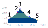
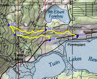
1.(9290ft,mile00) START-END WEST: Colorado Trail
crosses under Co82, east of settlment of Twin
Lakes
2.(10050ft,mile02) CT crosses creek
3.(10380ft,mile02) TOP: CT merges with road below
upper trailhead. Profile turns right down FR125.1B
4.(9620ft,mile04) FR1251B meets paved road at
lower trailhead
5.(9320ft,mile05) START-END EAST: jct Co82 - paved
road to Mount Elbert forebay and Lake View
Campground