| |
|
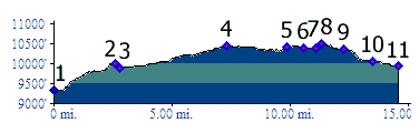
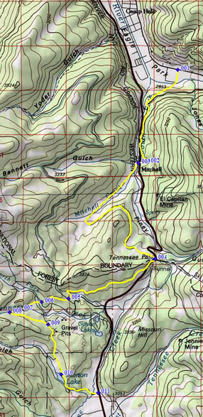
1.(9340ft,mile00) START-END NORTH: Colorado Trail turns
left onto FR741C before entering Camp Hale.
2.(10010ft,mile03) Colorado Trail shoulder summit m139.9
3.(9970ft,mile03) Colorado Trail crosses US24 on its way
to Tennessee Pass. Profile turns down US24.
4.(10424ft,mile08) CT Trailhead at top of Tennessee Pass
5.(10420ft,mile10) CT crosses Wurts Ditch Road
6.(10400ft,mile11) CT crosses Lily Lake Road
7.(10390ft,mile11) CT crosses west fork of Tennessee Creek
on bridge
8.(10500ft,mile12) TOP: profile leaves Colorado Trail by
turning hard right onto a jeep trail
9.(10350ft,mile13) profile stays right/downhill at fork
10.(10060ft,mile14) route comes out at Morton Lake
11.(9950ft,mile15) START-END SOUTH: US24 - road to Morton
Lake