| |
| |
CRK8 Dolores Rim(sh)
Canyon rims on the Colorado Plateau
come in all shapes, sizes, colors and conditions
of accessibility and popularity. The rim of
Dolores Canyon belongs to the less visited, and
more difficult to access areas. This short track
over unmarked jeep trails is well suited for
mountain bike travel. It contains just one short
section with great views of the canyon area. The
rest of the trip, you could be traveling on an
ordinary, low and rolling grassy plain.
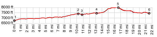
After turning off the paved road, the loop shown
in the profile keeps right and goes uphill at 2
junctions. It reaches a shoulder summit point at a
third junction.
From South. (described
downwards) Once on top of the ever so flat and
rounded hill, a left turnoff goes over a deeply
rutted but, but non rocky and easily rideable
double track trail towards the rim area of the
Dolores Canyon. Once if flattens out, it is
not far from the short section of the track, with
a great view of the canyon, and all the way to
Lone Cone Peak. Continuing on the well traveled track you have to
cross one gate toward a cow watering station.
Continuing on the road in westerly direction leads
back to CRK7. There is also a way to make the loop
longer and take one of the roads towards the north
to join Co149 at a lower point.
Dayride with this point as highest summit: PARTIALLY PAVED / UNPAVED ( < Dolores Rim Overlook(ow) | North Creek Rd - Hart's Draw Rd s(u) > ) CRK7 Dolores Rim(sh) : western end of Dove Creek > US666 west > Co149 north <> out and back on CRH1 east past the point of surface becoming rocky jeep trail >> Co149 north > CRK7 east > unmarked roads as shown on profile biack to jct with CRK7 > Co149 south > US666 east back to starting point: 442miles with 3170ft of climbing in 5:06hrs (garmin etrex30 m3:19.9 28) |
|
|
advertisement |
|
|
advertisement |