| |
| |
Dolores Canyon Overlook(ow)
When travelling on US606 through the
area around Dove Creek, the first impression is
that of a vast agricultural plain. But there are
some scenic wonders hidden in this area, and it is
hard to believe that a 2000 ft dirt road climb
connects a high plateau with one of the eastern
canyons of the Colorado Plateau area: the canyon
of the Dolores River
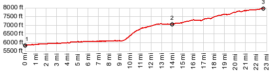
From the starting point of the profile quick
progress is possible on this road. It follows
close to the bottom of the canyon, mostly right
next to the yellow green grasses on the side of
the river. The road passes an informal campground,
then becomes a good gravel road and steeply climbs
up a side canyon of the Dolores. The plain that
the town Dove Creek sits on is about halfways in
elevation between the canyon and the overlook. Once on the agricultural plain around Dove Creek,
all the hard work is over. The slight inclined
slope of the road doesn't even make it look like
you are climbing a plateau. But soon Ute Mountain
and the Abajo Mountains in Utah disappear behind a
forest. The road goes out onto a tonque shaped
piece of plateau above the confluence of the
Dolores and a side canyon. You have to look around
to get beyond all the bushes and trees for a good
view in all directions of the canyon. Everytime I
have been here I have had the place to myself.
This is one of the least visited Colorado Plateau
canyon overlooks I know.
Dayride with this point as highest one way summit, and without two way summits: COMPLETELY UNPAVED ( < FR413 Benchmark Lookout s(u) | CRK8 Dolores Rim(sh) > ) Dolores Canyon Overlook(ow) : short distance east of Dolores Canyon Overlook(ow) > CR15 south > J Rd west > CR9 north > CR10 north > Dolores Canyon CR14F north to turnaround point at end of county maintainance << CR13Fsouth > CR10 south > J Rd east > CR15 north <> out and back to Dolores Canyon Overlook(ow > back to starting point on CR15: 48.7miles with 3590ft of climbing in 5:31hrs (garmin etrex30 m3:19.9.27) |
|
|
advertisement |
|
|
advertisement |