| |
|
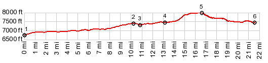
1.(mile00.0,6750ft) START-END SOUTH: low
point on Co149, immediately north of jct with Co491
2.(mile10.3,7420ft)Co141 Dove Creek - Naturita s(u)
3.(mile10.8,7310ft)profile turns right onto K8 road
4.(mile13.2,7450ft)profile stays right and uphill at
this jct
5.(mile16.6,8000ft)TOP:profile turns left from K8 onto
BLM4020
6,(mile21.6,7440ft) START-END NORTH: same as point 4
|