| |
| |
CR14N Mantle Ranch Rd(sh) This is a mountain/gravel
bikers back way into the Dinosaur Canyon
area. The road connects Echo Park, and
other points near the confluence of the
Green and Yampa Rivers with the rest of
the world from the east. Unlike the
connection from the west over Harper's
Corner road, both sides of this
rolling climb are unpaved. The most
interesting and scenic part is the upper
climb on the west side.
From
West. (described downwards) And
that comes during the first part of the
descent. The views are much more compelling
during the morning, when the direction of
the sun lights up the distant canyon walls
below. All the good views are towards the
west. In spring the Uinta mountains are a
wedge of white ice, seen in the distance,
framed by a V shaped cliff. The road descends between a
matchstick forest of small, dead trees to a
green bench between the Yampa river and Blue
Mountain. The river is still left to the
imagination, somewhere beyond the end of the
green plain. Even if climbing back out on
this side, by far the most energy is spent
on the ups and downs, that this bench road
needs to negotiate around the sidecanyons.
The course of the flowing water that made
this landscape maze is often a mystery.
Climbing out of the canyon to this summit is
just an afterthought, in terms of the
workout.
Dayride with this point
as highest summit:
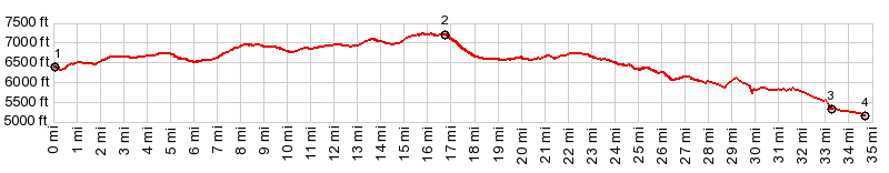
COMPLETELY UNPAVED: ( < CR78 Elkhead Reservoir(sh) | CR14 Deer Valley Rd via CR157 (sh) > ) CR14N Mantle Ranch Rd(sh) x2 : point along Bear Valley Rd, ~5miles from US40 at 6720 ft <> Bear Valley Rd west <> Mantle Ranch Rd(sh) <> down CR14N Mantle Ranch Rd <> turnaround point roughly where Blind Canyon crosses road: 47.0miles with 4470ft of climbing in 5:20hrs (garmin etrex30 m:20.5.9). |
|
|
advertisement |
|
|
advertisement |