| |
| |
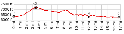
CR78 Elkhead Reservoir(sh)
This is a small paved climb north
of Craig. It is useful for cycling in making a
scenic, hilly, mostly unpaved but smooth surfaced
loop, via a reservoir, in conjunction with US40.
From South. (described
downwards) There are more houses scattered over
the top, and a residential street other than the
one profiled goes over a slightly higher point.
Following the main road, a now unpaved downhill
ties together a few spaced out farms, apparently
serving as retirement homes. One more short uphill
leads to a gap. From here the reservoir becomes
visible for the first time. The range visible to
the north has a set of distinctive knolls
named "Bears Ears". They also make a great
background behind the reservoir. After the road
crosses the dam, it joins another road, coming
down from the hills, and becomes paved again. The
road approaches US40 from a low balcony with view
over the Yampa River.
Dayride with this point as
highest summit
PARTIALLY PAVED / UNPAVED ( < | CR14N Mantle Ranch Rd s(u) > ) CR76/78 Elkhead Reservoir(sh) , addtional out and back : a park south of Craig <> out and back on Co394 east with turnaround point at end of pavement >> US40 east > Hayden with detour > CR76 north > CR76/78 Elkhead Reservoir(sh) <> out and back on a private road called Scenic Drive to high point >> Elkhead Reservoir > US40 west > sight seeing detours through Craig > back to starting point: 66.1miles with 2800ft of climbing in 5:39hrs (garmin etrex30 r4:20.5.8) |
|
|
advertisement |
|
|
advertisement |