| |
| |
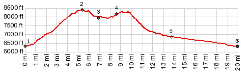
Brushy Point s(u)
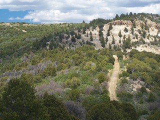
Brushy Point is a scenic
intersection of four jeep trails on a round hill
in the Roan Plateau. The obvious way to get there
is from the lower side of the northern approach to
Douglas Pass. It is
also an intermediate summit on a mountain bike
route to Douglas Pass, named the Rangely Loop.
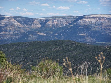
Views of the Roan Plateau sofar, have been views
of a landscape of patterns: various rectangular or
polygonally shaped ridges recede in all
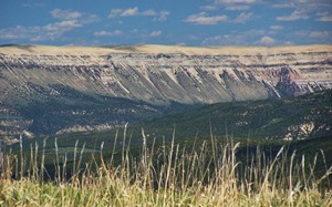
directions. From up here there the bright
Cathedral Bluffs to the north add a white shelf
into the landscape From North: This approach is not shown in
the profile. The next most obvious approach leaves
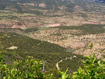
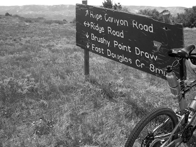
from CR27 following East Douglas Creek upstream.
The junction is located at a picturesque ranch.
The signed turnoff up Brushy Point Draw looks like
it could be a ranch road. But a sign identifies it
clearly. At first this approach feels a lot
easier. But for the last 700ft of climbing it gets
extremely steep and heavily rutted. Views of the
Cathedral Bluffs are payment for the climb. The
road joins the Rope Canyon approach immediately
before the highest point. From the rounded knoll
behind the junction the views can reach to the
Uintah Mountains in Utah.
From South. (described
downwards and shown in profile) Rather
than go down one of the other two relatively
direct approaches, the profile continues north
along Ridge Road. The name promises views and
delivers some. It does not hint at the steep ups
and downs that are still ahead. In order to
continue to Douglas
Pass (which is profiled on the Four A Ridge Rd
page), it is a good idea to pay attention to the
next several junctions, which have only limited
agreement with what some maps show. The first left after Brushy Point s(u) dead ends
on a hill. But it is worth taking it, because
later on it provides confidence that that was
indeed the wrong route. The next left and right
may lead into the valleys on more or less
abandoned roads. If heading for Douglas Pass it is
important to take a left after that - on BLM1242,
even if the direction first seems
counter-intuitive. If one misses this
turnoff, as I did on my second ride here, you end
up with Brushy Point as the highest summit, and a
second summit on Ridge Rd.
Getting down into the valley after the Ridge Road
summit can be tricky on a first or second ride.
Staying straight at the first junction.dead ends
at a gate and an abandoned road. Going right
before this dead end leads to another dead end on
top of a ridge. However there is an innocuous
turnoff in the midst of the same intersection,
leading back down to the Douglas Pass road, albeit
over an abandoned road, two closed gates, and
finally a hardly distinguishable track through the
sage brush. A wide track continues on east side of
Douglas Creek down valley till there is a suitable
road crossing. The profile is the recorded. route.
There may be better options available Dayride with this point as highest summit: PARTIALLY PAVED / UNPAVED / SINGLE TRACK ( | ZVI Rd s(u) >
) Dayrides with this point as intermediate
summit are on page: Four A Ridge Rd
s(u)
|
 That is
exactly what the profile on this page does. It
makes Brushy Point the summit and continues
directly down into the valley after the Ridge Rd
summit, as recorded by GPS with all my erroneous
detours edited out.
That is
exactly what the profile on this page does. It
makes Brushy Point the summit and continues
directly down into the valley after the Ridge Rd
summit, as recorded by GPS with all my erroneous
detours edited out.|
|
advertisement |
|
|
advertisement |