| |
|
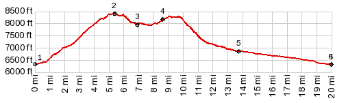
1.(00.0m,6320ft) START-END NORTH-1: jct Co139 - Rope Canyon Rod
2.(05.4m,8420ft) TOP: Brushy Point s(u)
3.(07.0m,7980ft) profile stays left on the ridge; right goes back down to Co139
4.(08.7m,8190ft) profile stays left
5.(13.8m.6860ft) profile rejoins Co139 and turns downhill
6.(19.9m,6320ft) START-END NORTH-2: same as point 1
|