| |
| |
Green Mountain Road s(u) Central Wyoming is a sea of sage
with a few islands of high needle forest. One
of those islands is Green Mountain, south of
Douglas. A nicely graveled loop road traverses
the high ridge, with an additional out and
back access road to an overlook.
Shortly after the Green Mtn Road
splits the grunt climb begins. This is not
terribly deep gravel or severe washboard. It's
the combination of the two. In any case, the
Granite Mountains are slowly starting to appear
from what seems like an aerial perpsective. The
forest promised from below, finally appears and
pretty much swallows up the road. But there are
still a few view points opening up to these
landwaves of the Granite Mountains below.
Eventually the road reaches a high point on this
Green Mountain Ridge in a high sage meadow with
a far view to the north also available.
But another road at the mentioned
junction does offer a way down to the north. It
is gated and labeled "Mine access road -no
public access". The profile follows the
remaining option heading back north on the
official Green Mountain Rd. A fairly steep
decent through straight woods leads to
moderately hot brake pads. There are no more
views until the road exits the forest. There is only one more junction
with an unlabeled but scenically impressive
track heading east across the sage brush.
Private land between here and US287 makes
following this option complicated. The profile stays on the Green
Mountain Loop Road. Combining Green Mountain
Loop Road with Mine Acess Road has a different
summit point: Green
Mtn Rd - Mine Acess Rd(sh).
Dayride with this point as
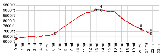
highest point: COMPLETELY UNPAVED ( < Stillwater Pass | Green Mtn Rd - Mine Acess Rd(sh) > ) Green Mountain Road s(u) , additional out and back : jct US287 - Green Mountain Rd > up Green Mtn Rd > Green Mtn Rd counterclockwise > Green Mtn Rd s(u) <> out and back to Wild Horse Point <> short separate out and back down Mine Access Rd > down eastern part of Green Mtn Rd <> out and back on unlabeled BLM Rd at jct with East Cottonwood Creek << turnaround point ~3.8miles one way with low point ~380ft below jct >> down Green Mountain > back to starting point at jct US287 - Green Mtn Rd: 42.3miles with 4250ft of climbing in 5:54hrs (garmin etrex32 m5:23.09.2). 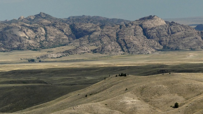 |
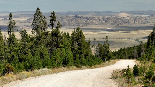 From East. (described
downwards) I was up here during Labor Day
weekend, and there seemed to be a whole city of
large camping semi trucks up here, occupying
most every crevice of the woods. The dirt road
is so wide and large that even these vehicles
made it up here. Shortly after the highest
point, a large junction features several signs.
One option towards the east is an out and back
to Wild Horse Point. After 3 miles you get some
additional views to the east and the Ferris
Range. There are no junctions with trails that
permit additional ways down from the viewpoint
road. It is strictly out and back.
From East. (described
downwards) I was up here during Labor Day
weekend, and there seemed to be a whole city of
large camping semi trucks up here, occupying
most every crevice of the woods. The dirt road
is so wide and large that even these vehicles
made it up here. Shortly after the highest
point, a large junction features several signs.
One option towards the east is an out and back
to Wild Horse Point. After 3 miles you get some
additional views to the east and the Ferris
Range. There are no junctions with trails that
permit additional ways down from the viewpoint
road. It is strictly out and back.|
|
advertisement |
|
|
advertisement |