| |
| |
CR171 Piedmont Rd s(u) Piedmont means "the foot of the
mountains", and these are large, far sweeping
feet, really more like the ruffled skirt of the
mountains. This summit strikes me as the
quintessential Wyoming gravel experience. How
can something with such vast views reqiore only
so little climbing? The wind, that was steadily
blowing into my face, also must have something
to do with it. If nothing stands in the way of
the wind - then nothing obstructs the view to
the far horizon either. A good workout was had
by all, and the views seemed infinite. This is one of several summits in
the area of rolling grasslands between Evanston
and the Uintah Mountains. This is a ranch road
and the unpaved surface is impeccably perfect
for fast biking.
From exit 238, the gravel road
follows Muddy Creek, a very common name in
Wyoming. But the valley is really something
special - very gently, ruled by a wildly curving
little stream bringing lots of water to the
thirsty cows. Adjacent valleys on both sides
have a much more drier appearance. The road climbs
almost imperceptibly but steadily. Piedmont is a
site of three Charcoal Kilns, together with
informational tablets that explain how they were
constructed by an enterprising business man, to
make charcoal with wood from the nearby Uinta
Mountains, in order to sell railroad ties to the
transcontinental railroad building effort, going
on nearby. Rather than staying on CR171 this
summit route takes the southern path over CR173.
Finally the road becomes fairly steep and climbs
over large rolling plain above treeline. In the
far distance the Uintah Mountains form a white rim
to this sweeping grassy scene. The junction with
Piedmont - Aspen Rd is immediately before the
summit. These road names are often shown wrong on
maps. 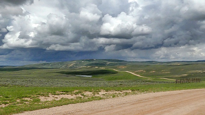 From West (described
downwards) A first sweeping decent leads down
towards a large breadloaf shape. At the next
junction I had to study a large paper map may to
clear up confusion about the current location.
Actually it just created new confusion, because
from a cyclist's point of view most options
available from here are not really shown on the
map. This was my first ride in this area and so
the profile continues on whatever road appears to
have the most usage, which was also the originally
planned loop. CR173 continues. It works. It gets
you back to pavement to complete the loop. Regular
residences become more common as the road
approaches pavement. If coming from the other direction
on Wy150 the junction with this gravel road is
easy to recognize. But you have to look out for a
special sign. Instead of a road sign, there is one
saying "road closed - your gps is wrong". The
profile includes Wy150 all the way back to
Evanston. It has a wide, delapidated shoulder
often with a badly executed rumble strip as wide
as a Mormon push cart. However the shoulder is so
huge, that riding on it is really no problem
whatsoever, especially on a wide tires.
Dayride with this point as
highest summit
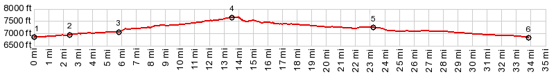
PARTIALLY PAVED / UNPAVED ( < CR180 Evanston Rd microwave tower | White Mountain Road via Rock Springs > ) CR171 Piedmont Rd , CR180 Evanston Rd eastern(sh) , CR180 Evanston Rd western(sh) , CR180 Evanston Rd eastern s(u) : jct I80 - US189 > up CR181 > CR180 east > CR180 Evanston Rd eastern s(u) > CR173 Piedmont Rd west > CR171 Piedmont Rd west > CR171 Piedmont Rd s(u) > CR173 west > Wy150 north > eastern Evanston I80 entrance > I80 east > CR180 east > CR180 Evanston Rd western(sh) > back to starting point at jct I80 - US189: 58.9miles with 2760ft of clilmbing in 5:54hrs (garmin etrex32x m5:23.6.14). |
|
|
advertisement |
|
|
advertisement |